IMAGES TAKEN NEAR TO
Sherford Street, BROMYARD, HR7 4DL
Introduction
This page details the photographs taken nearby to Sherford Street, HR7 4DL by members of the Geograph project.
The Geograph project started in 2005 with the aim of publishing, organising and preserving representative images for every square kilometre of Great Britain, Ireland and the Isle of Man.

There are currently over 7.5m images from over14,400 individuals and you can help contribute to the project by visiting https://www.geograph.org.uk
Image Map
Images are licensed for reuse under creativecommons.org/licenses/by-sa/2.0
Notes
- Clicking on the map will re-center to the selected point.
- The higher the marker number, the further away the image location is from the centre of the postcode.
Image Listing (464 Images Found)
Images are licensed for reuse under creativecommons.org/licenses/by-sa/2.0
Image
Details
Distance
1
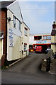
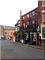
Sherford Street Garage, Bromyard
Accessed via a gap between houses on the east side of Sherford Street.
Image: © Jaggery
Taken: 19 Mar 2015
0.01 miles
2
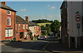
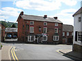
Sherford Street, Bromyard
The B4203 (one of several streets so-numbered in the vicinity) drops down to meet the A44 by-pass. On the left is part of the Crown and Sceptre Image The pale cottages down the hill are listed https://historicengland.org.uk/listing/the-list/list-entry/1307649?section=official-list-entry. On the immediate right is the splayed corner of the Time Machine Museum of Science Fiction, in a building that is also listed https://historicengland.org.uk/listing/the-list/list-entry/1082326?section=official-list-entry.
Image: © Derek Harper
Taken: 15 Jul 2021
0.01 miles
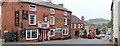
3
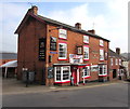
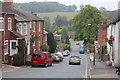
Crown & Sceptre pub in Bromyard
The early 19th century building in Sherford Street is at the top of a descent to the valley of the River Frome.
Image: © Jaggery
Taken: 19 Mar 2015
0.01 miles
4
Crown & Sceptre pub, Bromyard
On Sherford Street, the eastern edge of the town.
Image: © Pauline E
Taken: 18 May 2008
0.01 miles
5
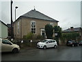
Former Congregational Chapel (Bromyard)
This building and its next door neighbour (old police station) were both derelict for many decades until being saved in the 2010s. This chapel looked horrific when I saw it in the 2009 Google Maps street-view, and would have looked like that since the chapel's closure in 1971. However, this now houses the Chapel Gallery, which is a nice new use.
Image: © Fabian Musto
Taken: 13 Oct 2019
0.02 miles
7
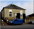
Converted former Congregational Chapel in Bromyard
Last used for religious services in 1971, now converted to residential use, viewed in March 2015.
Compare with this photo http://www.geograph.org.uk/photo/4348574 of dereliction in 2003.
The golden cockerel weather vane appears to be a recent addition.
Image: © Jaggery
Taken: 19 Mar 2015
0.02 miles
8
Bromyard - Flowerdew's cafe
On the southern edge of Market Square. In the distance, on steeply sloping Sherford Street is the Crown & Sceptre pub, at the time of photography no longer in business. It was open once again in July 2013.
Image: © Peter Whatley
Taken: 20 Oct 2012
0.02 miles
9
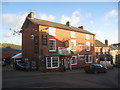
Bromyard Pubs - The Crown and Sceptre
Early nineteenth century. http://www.britishlistedbuildings.co.uk/en-151061-crown-and-sceptre-public-house-bromyard-
Image: © Jonathan Thacker
Taken: 22 Nov 2013
0.02 miles