IMAGES TAKEN NEAR TO
Wigmore, LEOMINSTER, HR6 9UP
Introduction
This page details the photographs taken nearby to HR6 9UP by members of the Geograph project.
The Geograph project started in 2005 with the aim of publishing, organising and preserving representative images for every square kilometre of Great Britain, Ireland and the Isle of Man.

There are currently over 7.5m images from over14,400 individuals and you can help contribute to the project by visiting https://www.geograph.org.uk
Image Map (Loading...)


Getting Data...Please wait
Leaflet Map data © OpenStreetMap
Images are licensed for reuse under creativecommons.org/licenses/by-sa/2.0
Notes
- Clicking on the map will re-center to the selected point.
- The higher the marker number, the further away the image location is from the centre of the postcode.
Image Listing (28 Images Found)
Images are licensed for reuse under creativecommons.org/licenses/by-sa/2.0
Image
Details
Distance
1
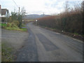
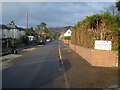
Ford Street reaches the village boundary
View north-east along the road to Ludlow as it leaves Wigmore. Bringewood west of Ludlow on the horizon.
Image: © Trevor Rickard
Taken: 24 Nov 2008
0.02 miles
2
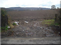
Course of the Roman road.
Looking south-east across a ploughed field to Yatton Hill in the distance. This was once Watling Street West (or Welsh Watling Street), running from Viroconium (Wroxeter) to Magna (Kenchester) via Branogenivm (Leintwardine) and then on to Isca Silurum (Caerleon) in South Wales. All trace of the road in this area was ploughed up a long time ago!
http://www.smr.herefordshire.gov.uk/roman/roads.htm
Image: © Trevor Rickard
Taken: 24 Nov 2008
0.12 miles
3
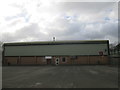
Leisure Centre (Wigmore)
Here is the leisure centre by Wigmore High School. This leisure centre is not open that occasionally however.
Image: © Fabian Musto
Taken: 20 Feb 2018
0.15 miles
4
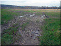
Arable land north of Wigmore
From the lane looking north-west across reclaimed land that was once part of the Wigmore Glacial Lake at the end of the Ice Age. The northern end of the Wigmore Rolls woodland on the left.
Image: © Trevor Rickard
Taken: 24 Nov 2008
0.15 miles
5
Ford Street - 1
From the entrance to The Old Vicarage Care Home looking north-west to the town centre.
Image: © Trevor Rickard
Taken: 24 Nov 2008
0.15 miles
6
![Wigmore features [1]](https://s2.geograph.org.uk/geophotos/06/96/73/6967326_08ff33e1_120x120.jpg)
Wigmore features [1]
An information board outside the village hall in Ford Street.
The village of Wigmore is set astride the A4110 road some 8 miles west of Ludlow in the northwest part of Herefordshire. An Anglo-Saxon village which, after the building of the castle, became a small but thriving market town. Wigmore declined when the castle owners moved their administrative centre to Ludlow and reverted to village status.
Image: © Michael Dibb
Taken: 1 Jun 2021
0.17 miles
7
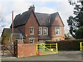
The Old Vicarage (Wigmore)
This odd-looking house is now a residential home.
Image: © Fabian Musto
Taken: 20 Feb 2018
0.17 miles
8
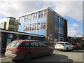
Wigmore High School
I believe this was built around the late 1960s, after the high school at Weobley was built. The clouds reflecting on the windows are nice to look at.
Image: © Fabian Musto
Taken: 20 Feb 2018
0.17 miles
9
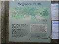
Sign to Wigmore Castle
Very useful to travellers if they do not know the way to enter the castle.
Instead of a visitor centre being built and having a car park there, they put the car park in the village hall instead.
Image: © Fabian Musto
Taken: 20 Feb 2018
0.17 miles
10
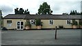
Wigmore Village Hall
Here is the wide village hall structure at Wigmore, which is placed by the high school. Visitors to the village (e.g. visiting the castle) can park here.
Image: © Fabian Musto
Taken: 21 Aug 2018
0.18 miles