IMAGES TAKEN NEAR TO
Yatton, LEOMINSTER, HR6 9TP
Introduction
This page details the photographs taken nearby to HR6 9TP by members of the Geograph project.
The Geograph project started in 2005 with the aim of publishing, organising and preserving representative images for every square kilometre of Great Britain, Ireland and the Isle of Man.

There are currently over 7.5m images from over14,400 individuals and you can help contribute to the project by visiting https://www.geograph.org.uk
Image Map (Loading...)


Getting Data...Please wait
Leaflet Map data © OpenStreetMap
Images are licensed for reuse under creativecommons.org/licenses/by-sa/2.0
Notes
- Clicking on the map will re-center to the selected point.
- The higher the marker number, the further away the image location is from the centre of the postcode.
Image Listing (15 Images Found)
Images are licensed for reuse under creativecommons.org/licenses/by-sa/2.0
Image
Details
Distance
1
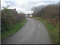
Yatton Marsh
Small group of houses sitting on what would have been lake bed in the ice age as this whole area was part of the Wigmore Glacial Lake. The waters have retreated and the land has been drained, but it is still marshy in places, hence the name.
Image: © Trevor Rickard
Taken: 24 Nov 2008
0.05 miles
2
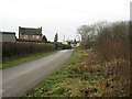
Yatton Marsh
Wetland on the right, scattered houses making up another part of Yatton built on what is probably drier ground on the left.
Image: © Richard Webb
Taken: 27 Dec 2006
0.08 miles
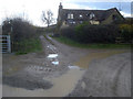
3
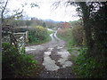
Entrance to Yatton Marsh Farm
Looking north-west down the entrance track to where it meets the lane. The house is through the gate on the left.
Image: © Trevor Rickard
Taken: 24 Nov 2008
0.13 miles
4
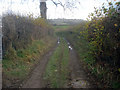
Farm track north of Yatton
Looking northwards along the narrow track with Gatley Hill on the horizon.
Image: © Trevor Rickard
Taken: 24 Nov 2008
0.16 miles
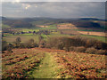
5

View from Croft Ambrey Hill fort
Yatton is just about visible in the centre.
Image: © Eric Marsh
Taken: 20 Aug 2013
0.16 miles
6
Long horned cattle near Yatton
At first I thought these two were Highland but they seem too red in colour, so possibly are some other rare breed.
Image: © Jeremy Bolwell
Taken: 7 Apr 2011
0.17 miles
7
Footpath to Yatton
Looking west down and then along what is virtually a straight-line path to the few houses which make up Yatton in the valley bottom.
Image: © Trevor Rickard
Taken: 24 Nov 2008
0.18 miles
8
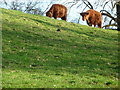
Long horned cattle near Yatton
Happily grazing this steep pasture above Yatton.
Image: © Jeremy Bolwell
Taken: 7 Apr 2011
0.18 miles
9
House on the bend in the lane at Yatton Marsh
Looking along the farm track taking the Wigmore Loop Walk northwards, which is waymarked on the finger post on the left.
http://www.herefordshire.gov.uk/docs/CommunityAndLiving/Wigmore_Loop_Walk.pdf
Image: © Trevor Rickard
Taken: 24 Nov 2008
0.18 miles
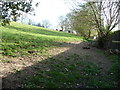
10
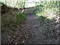
Sunken path to Yatton
Often used by walkers and horse riders it seems these days.
Image: © Jeremy Bolwell
Taken: 7 Apr 2011
0.19 miles