IMAGES TAKEN NEAR TO
Kingsland, LEOMINSTER, HR6 9QE
Introduction
This page details the photographs taken nearby to HR6 9QE by members of the Geograph project.
The Geograph project started in 2005 with the aim of publishing, organising and preserving representative images for every square kilometre of Great Britain, Ireland and the Isle of Man.

There are currently over 7.5m images from over14,400 individuals and you can help contribute to the project by visiting https://www.geograph.org.uk
Image Map
Images are licensed for reuse under creativecommons.org/licenses/by-sa/2.0
Notes
- Clicking on the map will re-center to the selected point.
- The higher the marker number, the further away the image location is from the centre of the postcode.
Image Listing (6 Images Found)
Images are licensed for reuse under creativecommons.org/licenses/by-sa/2.0
Image
Details
Distance
1
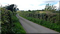
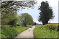
Ledicot Lane
Narrow country lane between Mortimer's Cross and Ledicot.
Image: © Jonathan Billinger
Taken: 31 Aug 2017
0.06 miles
2
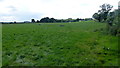
Pasture land
View to the south-west of Hereford Lane; rich Herefordshire pastures.
Image: © Jonathan Billinger
Taken: 31 Aug 2017
0.08 miles
3
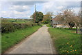
Hereford Lane at Lower Cross Farm
Hereford Lane is a Roman road but in more recent times the battle of Mortimer's Cross was fought in the adjoining fields in 1461 during the Wars of the Roses.
Image: © Roger Davies
Taken: 6 May 2012
0.11 miles
4
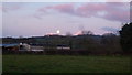
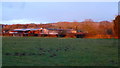
Setting Super Moon
Early morning glimpse of the super moon just about to set over Shobdon Hill.
Image: © Jonathan Billinger
Taken: 1 Feb 2018
0.15 miles
5
One week after the super moon
The focus now is of a rising February morning sun (behind the camera) illuminating the same scene as Image
Image: © Jonathan Billinger
Taken: 8 Feb 2018
0.15 miles
6
Hereford Lane in early May looking south
Image: © Roger Davies
Taken: 6 May 2012
0.21 miles