
IMAGES TAKEN NEAR TO
Lucton, LEOMINSTER, HR6 9PN
Introduction
This page details the photographs taken nearby to HR6 9PN by members of the Geograph project.
The Geograph project started in 2005 with the aim of publishing, organising and preserving representative images for every square kilometre of Great Britain, Ireland and the Isle of Man.

There are currently over 7.5m images from over14,400 individuals and you can help contribute to the project by visiting https://www.geograph.org.uk
Image Map
Images are licensed for reuse under creativecommons.org/licenses/by-sa/2.0
Notes
- Clicking on the map will re-center to the selected point.
- The higher the marker number, the further away the image location is from the centre of the postcode.
Image Listing (11 Images Found)
Images are licensed for reuse under creativecommons.org/licenses/by-sa/2.0
Image
Details
Distance
2
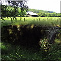
Covered reservoir
On the edge of School Wood, alongside an overgrown footpath.
Image: © Z Pryce
Taken: 15 Jul 2019
0.15 miles
3

Lucton School
Banner advertising the school and some of the grounds / sports facilities. The school closed briefly in the late 20th century but was swiftly reopened. The colours are used by the "former pupils" rugby club which has been very successful in recent years.
Image: © Richard Webb
Taken: 9 Aug 2010
0.16 miles
4
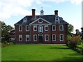
Lucton School
Lucton School, the building is Grade II* listed https://historicengland.org.uk/listing/the-list/list-entry/1082082 and dates from 1708. The figure in the alcove on front of the building is of the founder John Pierrepont, he made his fortune as a vintner in London. Today it is an independent co-educational school.
Image: © Philip Halling
Taken: 16 Oct 2019
0.18 miles
5
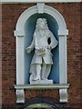
Statue of John Pierrpont, Lucton School
Statue of John Pierrpont on the front of Lucton School. He was the school's founder in 1708, he made his fortune as a vinter in London.
Image: © Philip Halling
Taken: 16 Oct 2019
0.18 miles
6
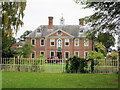
Lucton School
This fine building was erected in 1708. The central bay contains a niche with semi-circular head containing a painted stone statue of the founder, John Pierrepont. The clock and weather vane are all original and the whole is Grade II* listed with English Heritage Building ID: 149436. See: http://www.britishlistedbuildings.co.uk/en-149436-lucton-school-lucton-
Image: © Stuart Logan
Taken: 22 Sep 2013
0.18 miles
7
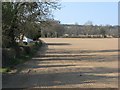
Newly sown field
Just outside Lucton, looking up the dip slope of the great limestone ridge that starts as Wenlock Edge and continues on into Radnorshire. The pale soil colour contrasts with the deep red found just to the southeast.
Image: © Richard Webb
Taken: 1 Apr 2007
0.19 miles
8

Pastoral scene near Lucton
I took this whilst cycling from Carmarthen to Mirfield having given my old car to my daughter. The only clues as to its whereabouts are a list of villages on my route and 'Lucton' written on the back of the print. I managed to locate the scene using Street View and the satellite image with grid references on the Bedfordshire Natural History Society website.
Image: © Humphrey Bolton
Taken: 5 Jul 1999
0.19 miles
9
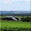
Shed above Lucton
View out over the hills between Leominster and Tenbury. The top of the Worcestershire Beacon can be seen to the extreme right.
Image: © Z Pryce
Taken: 15 Jul 2019
0.23 miles
