IMAGES TAKEN NEAR TO
Stansbatch, LEOMINSTER, HR6 9LW
Introduction
This page details the photographs taken nearby to HR6 9LW by members of the Geograph project.
The Geograph project started in 2005 with the aim of publishing, organising and preserving representative images for every square kilometre of Great Britain, Ireland and the Isle of Man.

There are currently over 7.5m images from over14,400 individuals and you can help contribute to the project by visiting https://www.geograph.org.uk
Image Map (Loading...)


Getting Data...Please wait
Leaflet Map data © OpenStreetMap
Images are licensed for reuse under creativecommons.org/licenses/by-sa/2.0
Notes
- Clicking on the map will re-center to the selected point.
- The higher the marker number, the further away the image location is from the centre of the postcode.
Image Listing (3 Images Found)
Images are licensed for reuse under creativecommons.org/licenses/by-sa/2.0
Image
Details
Distance
1
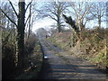
Course of the Kington & Presteigne Railway - 2
Looking north-west from Broadford along the old trackbed towards Presteigne.
http://www.smr.herefordshire.gov.uk/post-medieval/railways/king_prest.htm
Image: © Trevor Rickard
Taken: 18 Feb 2008
0.12 miles
2
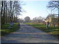
Entrance to Highland Farm
Well made-up farm road heads off north-west from the lane at Broadford, then turns sharp right past some sheds.
Image: © Trevor Rickard
Taken: 18 Feb 2008
0.20 miles
3
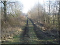
Old railway trackbed near Ashley
View south-east from the point where the old Presteigne branch line crosses the entrance road to Ashley.
http://www.smr.herefordshire.gov.uk/post-medieval/railways/king_prest.htm
Image: © Trevor Rickard
Taken: 18 Feb 2008
0.23 miles