IMAGES TAKEN NEAR TO
Eardisland, LEOMINSTER, HR6 9AX
Introduction
This page details the photographs taken nearby to HR6 9AX by members of the Geograph project.
The Geograph project started in 2005 with the aim of publishing, organising and preserving representative images for every square kilometre of Great Britain, Ireland and the Isle of Man.

There are currently over 7.5m images from over14,400 individuals and you can help contribute to the project by visiting https://www.geograph.org.uk
Image Map (Loading...)


Getting Data...Please wait
Leaflet Map data © OpenStreetMap
Images are licensed for reuse under creativecommons.org/licenses/by-sa/2.0
Notes
- Clicking on the map will re-center to the selected point.
- The higher the marker number, the further away the image location is from the centre of the postcode.
Image Listing (4 Images Found)
Images are licensed for reuse under creativecommons.org/licenses/by-sa/2.0
Image
Details
Distance
3
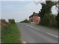
Lawton Summit
The B4529 briefly surmounts the 100 metre contour beyond the farm.
Image: © Peter Whatley
Taken: 19 Apr 2010
0.13 miles