IMAGES TAKEN NEAR TO
Blanchard Close, LEOMINSTER, HR6 8SH
Introduction
This page details the photographs taken nearby to Blanchard Close, HR6 8SH by members of the Geograph project.
The Geograph project started in 2005 with the aim of publishing, organising and preserving representative images for every square kilometre of Great Britain, Ireland and the Isle of Man.

There are currently over 7.5m images from over14,400 individuals and you can help contribute to the project by visiting https://www.geograph.org.uk
Image Map
Images are licensed for reuse under creativecommons.org/licenses/by-sa/2.0
Notes
- Clicking on the map will re-center to the selected point.
- The higher the marker number, the further away the image location is from the centre of the postcode.
Image Listing (20 Images Found)
Images are licensed for reuse under creativecommons.org/licenses/by-sa/2.0
Image
Details
Distance
1

Houses backing onto Ginhall Lane
Houses backing onto Ginhall Lane on the edge of Leominster.
Image: © Philip Halling
Taken: 23 Jul 2016
0.09 miles
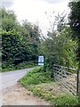
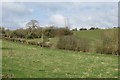
3
Private drive, public path
The path gives access to the Lugg flood plain on its way north and west from Ginhall Lane, towards Cholstrey.
Image: © Jonathan Billinger
Taken: 12 Oct 2017
0.14 miles
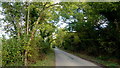
4

Field entrance, Cusneh Hill
Field entrance of Ginhall Lane on Cusneh Hill on the edge of Leominster.
Image: © Philip Halling
Taken: 23 Jul 2016
0.16 miles
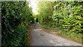
5
Ginhall Lane
Looking east towards Leominster town centre.
Image: © Jonathan Billinger
Taken: 12 Oct 2017
0.16 miles
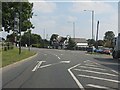
6
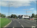
B4360 junction with A44
The white building at the centre of the photograph is the Baron's Cross Inn.
Image: © Stuart Logan
Taken: 21 Sep 2013
0.17 miles
7
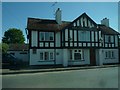
The Barons Cross (Leominster)
This popular pub is placed by the A44 road, and there has been a pub here since the 17th century. Originally housed in a cottage, the building was replaced in the early 20th century with a timber-framed building.
Image: © Fabian Musto
Taken: 29 May 2020
0.17 miles
8
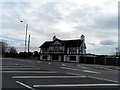
Barons Cross Inn
At the junction of the A44 and B4529. An awful lot of tarmac and chevrons.
Image: © Bikeboy
Taken: 9 Apr 2014
0.18 miles
9
Cursneh Hill
The big power line runs to/from a substation just outside Kington.
Image: © Richard Webb
Taken: 4 Apr 2015
0.18 miles
10
Barons Cross junction, Leominster
The A44 is, curiously, the minor route at the junction.
Image: © Peter Whatley
Taken: 1 Sep 2011
0.18 miles