IMAGES TAKEN NEAR TO
George Street, LEOMINSTER, HR6 8JZ
Introduction
This page details the photographs taken nearby to George Street, HR6 8JZ by members of the Geograph project.
The Geograph project started in 2005 with the aim of publishing, organising and preserving representative images for every square kilometre of Great Britain, Ireland and the Isle of Man.

There are currently over 7.5m images from over14,400 individuals and you can help contribute to the project by visiting https://www.geograph.org.uk
Image Map (Loading...)


Getting Data...Please wait
Leaflet Map data © OpenStreetMap
Images are licensed for reuse under creativecommons.org/licenses/by-sa/2.0
Notes
- Clicking on the map will re-center to the selected point.
- The higher the marker number, the further away the image location is from the centre of the postcode.
Image Listing (70 Images Found)
Images are licensed for reuse under creativecommons.org/licenses/by-sa/2.0
Image
Details
Distance
1
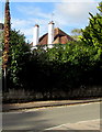
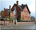
White chimneystacks in Leominster
On a house set back from the west side of the B4361 South Street.
Image: © Jaggery
Taken: 16 Oct 2019
0.09 miles
2
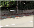
From Hereford Road to South Street, Leominster
Name signs on the west side of the B4361.
Image: © Jaggery
Taken: 16 Oct 2019
0.10 miles
3
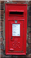
George VI postbox on South Street, Leominster
Postbox No. HR6 894.
Image: © JThomas
Taken: 2 Nov 2019
0.10 miles
4
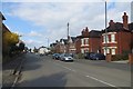
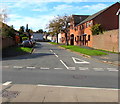
South Street, Leominster
It becomes Hereford Road further south and used to be the A49.
Image: © Richard Webb
Taken: 4 Apr 2015
0.11 miles
5
From South Street to Hereford Road, Leominster
Adjacent name signs alongside the B4361 mark the transition from South Street to Hereford Road.
Image: © Jaggery
Taken: 22 Apr 2012
0.11 miles
6
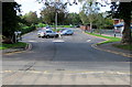
West along Churchill Avenue, Leominster
Across the B4361 South Street along Churchill Avenue towards Gateway Lane and Croft Street.
Image: © Jaggery
Taken: 16 Oct 2019
0.11 miles
7
Entrance to Leominster Infants' School
On the west side of Hereford Road.
Image: © Jaggery
Taken: 22 Apr 2012
0.11 miles
8
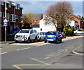
H is for Hospital, South Street, Leominster
The white-on-blue sign faces northbound traffic on the B4361 South Street on the approach to Leominster Community Hospital.
Image: © Jaggery
Taken: 16 Oct 2019
0.11 miles
9
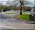
Access road to Leominster Primary School
From the west side of the B4361 Hereford Road in Leominster.
Image: © Jaggery
Taken: 16 Oct 2019
0.11 miles
10
Earl Mortimer College & Sixth Form Centre nameboard, Leominster
On the east side of South Street.
Image: © Jaggery
Taken: 16 Oct 2019
0.12 miles