IMAGES TAKEN NEAR TO
South Street, LEOMINSTER, HR6 8JF
Introduction
This page details the photographs taken nearby to South Street, HR6 8JF by members of the Geograph project.
The Geograph project started in 2005 with the aim of publishing, organising and preserving representative images for every square kilometre of Great Britain, Ireland and the Isle of Man.

There are currently over 7.5m images from over14,400 individuals and you can help contribute to the project by visiting https://www.geograph.org.uk
Image Map (Loading...)


Getting Data...Please wait
Leaflet Map data © OpenStreetMap
Images are licensed for reuse under creativecommons.org/licenses/by-sa/2.0
Notes
- Clicking on the map will re-center to the selected point.
- The higher the marker number, the further away the image location is from the centre of the postcode.
Image Listing (418 Images Found)
Images are licensed for reuse under creativecommons.org/licenses/by-sa/2.0
Image
Details
Distance
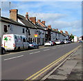
1
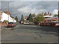
South Street at the community hospital
The petrol station is now a tile store!
Image: © Peter Whatley
Taken: 25 Oct 2011
0.01 miles
2
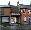
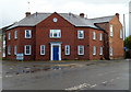
Entrance to Downes Court, Leominster
Viewed across South Street. The name E.E.DOWNES on the wall over the entrance, and, hanging from a bracket, a small green depiction of what looks like an anvil, suggest that the flats in Downes Court occupy the site of a former smithy.
A plaque on the house on the right at upstairs level shows JUBILEE COTTAGE and a faded year which could be 1890. If so, then it was named in celebration of Queen Victoria's Golden Jubilee in 1887.
Image: © Jaggery
Taken: 22 Apr 2012
0.01 miles
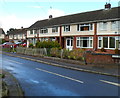
3
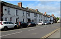
On-street parking, South Street, Leominster
On the west side of the B4361 South Street.
Image: © Jaggery
Taken: 16 Oct 2019
0.01 miles
4
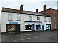
Leominster Angling
The South Street shop is next door to Neil Postons antique & fine furniture restoration premises.
Image: © Jaggery
Taken: 22 Apr 2012
0.02 miles
5
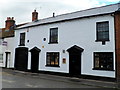
Formerly The Black Horse pub, Leominster
Viewed across South Street in April 2012. The white and jet black colours remain as a reminder that this used to be The Black Horse pub.
Image: © Jaggery
Taken: 22 Apr 2012
0.02 miles
6
Cennick Court, Leominster
Flats on the corner of South Street and Coningsby Road. A plaque https://www.geograph.org.uk/photo/6311902 on the wall records the official opening of Cennick Court on November 21st 2003 by Bill Wiggin MP.
Image: © Jaggery
Taken: 22 Apr 2012
0.03 miles
7
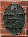
Cennick Court plaque, Leominster
The Marches Housing Association plaque is on the wall here. https://www.geograph.org.uk/photo/3815805
Image: © Jaggery
Taken: 16 Oct 2019
0.03 miles
8
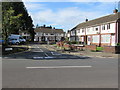
Hawthorne Place in Leominster
Cul-de-sac on the west side of the B4361 South Street.
Image: © Jaggery
Taken: 16 Oct 2019
0.03 miles
9
On-street parking, South Street, Leominster
Parking allowed on the west side of the B4361 South Street.
Double yellow lines on the east side indicate no parking at any time.
Image: © Jaggery
Taken: 16 Oct 2019
0.03 miles
10
Hawthorne Place, Leominster
A cul-de-sac on the west side of South Street.
Image: © Jaggery
Taken: 22 Apr 2012
0.04 miles