IMAGES TAKEN NEAR TO
Bradbury Close, LEOMINSTER, HR6 8FJ
Introduction
This page details the photographs taken nearby to Bradbury Close, HR6 8FJ by members of the Geograph project.
The Geograph project started in 2005 with the aim of publishing, organising and preserving representative images for every square kilometre of Great Britain, Ireland and the Isle of Man.

There are currently over 7.5m images from over14,400 individuals and you can help contribute to the project by visiting https://www.geograph.org.uk
Image Map
Images are licensed for reuse under creativecommons.org/licenses/by-sa/2.0
Notes
- Clicking on the map will re-center to the selected point.
- The higher the marker number, the further away the image location is from the centre of the postcode.
Image Listing (74 Images Found)
Images are licensed for reuse under creativecommons.org/licenses/by-sa/2.0
Image
Details
Distance
1
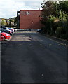
Entrance road to Earl Mortimer College, Leominster
From the east side of South Street. Earl Mortimer College & Sixth Form Centre opened in 2010, replacing Minster College.
Image: © Jaggery
Taken: 16 Oct 2019
0.05 miles
2
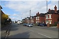
South Street, Leominster
It becomes Hereford Road further south and used to be the A49.
Image: © Richard Webb
Taken: 4 Apr 2015
0.05 miles
3

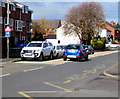
Colourful ambulance, South Street, Leominster
Community First Responder RC515 is parked near Leominster Community Hospital.
Image: © Jaggery
Taken: 16 Oct 2019
0.06 miles
4
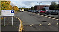
Part-time public pay & display car park on the east side of South Street, Leominster
The notice on the left states that this is a public pay & display car park at evenings, weekends and College holidays only. It is a private car park for Earl Mortimer College & Sixth Form Centre from 7am until 3:30pm - see tariff notice for College term times.
Image: © Jaggery
Taken: 16 Oct 2019
0.06 miles
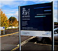
5
Earl Mortimer College
Earl Mortimer College and Sixth Form Centre.
Image: © Philip Halling
Taken: 17 Apr 2022
0.06 miles
6
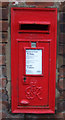
George VI postbox on South Street, Leominster
Postbox No. HR6 894.
Image: © JThomas
Taken: 2 Nov 2019
0.06 miles
7
Earl Mortimer College & Sixth Form Centre nameboard, Leominster
On the east side of South Street.
Image: © Jaggery
Taken: 16 Oct 2019
0.06 miles
8
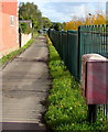
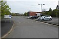
Path on the east side of South Street, Leominster
The red box is a Royal Mail drop box. https://www.geograph.org.uk/photo/6301250
Image: © Jaggery
Taken: 16 Oct 2019
0.07 miles
9
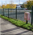
Faded red Royal Mail drop box, Leominster
Located here. https://www.geograph.org.uk/photo/6301244
Image: © Jaggery
Taken: 16 Oct 2019
0.07 miles
10
H is for Hospital, South Street, Leominster
The white-on-blue sign faces northbound traffic on the B4361 South Street on the approach to Leominster Community Hospital.
Image: © Jaggery
Taken: 16 Oct 2019
0.07 miles