IMAGES TAKEN NEAR TO
Hamnish, LEOMINSTER, HR6 0QN
Introduction
This page details the photographs taken nearby to HR6 0QN by members of the Geograph project.
The Geograph project started in 2005 with the aim of publishing, organising and preserving representative images for every square kilometre of Great Britain, Ireland and the Isle of Man.

There are currently over 7.5m images from over14,400 individuals and you can help contribute to the project by visiting https://www.geograph.org.uk
Image Map (Loading...)


Getting Data...Please wait
Leaflet Map data © OpenStreetMap
Images are licensed for reuse under creativecommons.org/licenses/by-sa/2.0
Notes
- Clicking on the map will re-center to the selected point.
- The higher the marker number, the further away the image location is from the centre of the postcode.
Image Listing (5 Images Found)
Images are licensed for reuse under creativecommons.org/licenses/by-sa/2.0
Image
Details
Distance
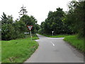
1
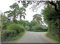
Un-named lane junction west of Holly Brook
Image: © Stuart Logan
Taken: 22 Sep 2013
0.14 miles
3
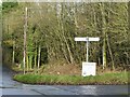
Crossroads, Stratford
This road used to be busy as a Leominster avoidance route if using the A417. Since the bypass it is much quieter. Two village halls use the signposts for notices advertising events. Puddlestone here, and Hamnish have one on the other side of the road.
Image: © Richard Webb
Taken: 6 Dec 2021
0.18 miles
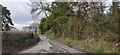
4
Country crossroads
Country crossroads to the north of Steen's Bridge.
Image: © Philip Halling
Taken: 25 Nov 2016
0.19 miles
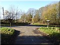
5
Meadow Bank crossroads
A caravan park is hidden by the trees on the far left of the junction.
Image: © Peter Whatley
Taken: 8 Sep 2008
0.20 miles