IMAGES TAKEN NEAR TO
Hengrave Green, LEOMINSTER, HR6 0JL
Introduction
This page details the photographs taken nearby to Hengrave Green, HR6 0JL by members of the Geograph project.
The Geograph project started in 2005 with the aim of publishing, organising and preserving representative images for every square kilometre of Great Britain, Ireland and the Isle of Man.

There are currently over 7.5m images from over14,400 individuals and you can help contribute to the project by visiting https://www.geograph.org.uk
Image Map
Images are licensed for reuse under creativecommons.org/licenses/by-sa/2.0
Notes
- Clicking on the map will re-center to the selected point.
- The higher the marker number, the further away the image location is from the centre of the postcode.
Image Listing (19 Images Found)
Images are licensed for reuse under creativecommons.org/licenses/by-sa/2.0
Image
Details
Distance
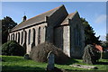
2
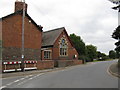
Ivington
Between the church and school.
Image: © Richard Webb
Taken: 15 Feb 2014
0.09 miles
4
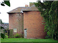
Oast House at Chipps House, Ivington
Image: © Oast House Archive
Taken: 30 Aug 2015
0.10 miles
5
Oast House at Chipps House, Ivington
Image: © Oast House Archive
Taken: 30 Aug 2015
0.10 miles
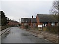
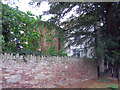
8
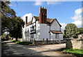
Chipps House, Ivington
Large 17th century farmhouse next to the church. Still very much a working farm.
Image: © Philip Pankhurst
Taken: 4 Apr 2010
0.12 miles
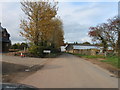
9
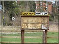
Look Now' What's On
Noticeboard, Ivington. I wonder if they still have a football team here. One operated in the North Herefordshire League in the 1980s.
Image: © Richard Webb
Taken: 15 Feb 2014
0.13 miles
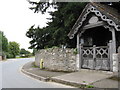
10
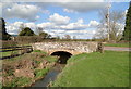
Bridge at Ivington school
One of a series of functional but elegant stone bridges in the area.
Image: © Philip Pankhurst
Taken: 4 Apr 2010
0.13 miles