IMAGES TAKEN NEAR TO
Leysters, LEOMINSTER, HR6 0HP
Introduction
This page details the photographs taken nearby to HR6 0HP by members of the Geograph project.
The Geograph project started in 2005 with the aim of publishing, organising and preserving representative images for every square kilometre of Great Britain, Ireland and the Isle of Man.

There are currently over 7.5m images from over14,400 individuals and you can help contribute to the project by visiting https://www.geograph.org.uk
Image Map
Images are licensed for reuse under creativecommons.org/licenses/by-sa/2.0
Notes
- Clicking on the map will re-center to the selected point.
- The higher the marker number, the further away the image location is from the centre of the postcode.
Image Listing (8 Images Found)
Images are licensed for reuse under creativecommons.org/licenses/by-sa/2.0
Image
Details
Distance
2
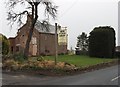
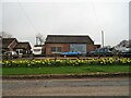
The Ash
Ash Farm, Leysters. Like many surviving farms has diversified into retail. One of the many outlets of quality food that has turned the Ludlow area into a tourist attraction.
The farm is on the Leominster-Tenbury road at the top of the infamous Raddle Bank, a steep bendy hill where the Bromyard plateau falls to the Teme Valley.
Image: © Richard Webb
Taken: 25 Dec 2006
0.10 miles
5
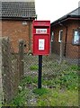
Elizabeth II postbox, Leysters Pole
Postbox No. HR6 947.
See Image] for context.
Image: © JThomas
Taken: 17 Apr 2023
0.17 miles
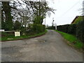
6
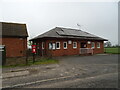
Leysters and Middleton Village Hall
Showing position of Postbox No. HR6 947.
See Image] for postbox.
Image: © JThomas
Taken: 17 Apr 2023
0.17 miles
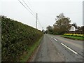
7
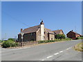
Pole Farm House
Beside the A4112 at Leysters
Image: © Eirian Evans
Taken: 28 Jun 2018
0.18 miles