IMAGES TAKEN NEAR TO
Kimbolton, LEOMINSTER, HR6 0ER
Introduction
This page details the photographs taken nearby to HR6 0ER by members of the Geograph project.
The Geograph project started in 2005 with the aim of publishing, organising and preserving representative images for every square kilometre of Great Britain, Ireland and the Isle of Man.

There are currently over 7.5m images from over14,400 individuals and you can help contribute to the project by visiting https://www.geograph.org.uk
Image Map
Images are licensed for reuse under creativecommons.org/licenses/by-sa/2.0
Notes
- Clicking on the map will re-center to the selected point.
- The higher the marker number, the further away the image location is from the centre of the postcode.
Image Listing (4 Images Found)
Images are licensed for reuse under creativecommons.org/licenses/by-sa/2.0
Image
Details
Distance
1
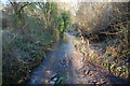
Ford at Lower Bach
This ford is found on the byway leading up from Lower Bach. The gentleman from the house advised me that he used to travel up the byway regularly in his Citroen. 4X4's are required these days. My 1500th addition to Geograph.
http://youtu.be/QjhE7E_3ag8
Image: © John Walton
Taken: 28 Dec 2014
0.07 miles
2
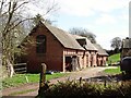
The Bach
Fine old barn not yet turned into a house.
Image: © Richard Webb
Taken: 1 Apr 2006
0.07 miles