IMAGES TAKEN NEAR TO
Newchurch, KINGTON, HR5 3QR
Introduction
This page details the photographs taken nearby to HR5 3QR by members of the Geograph project.
The Geograph project started in 2005 with the aim of publishing, organising and preserving representative images for every square kilometre of Great Britain, Ireland and the Isle of Man.

There are currently over 7.5m images from over14,400 individuals and you can help contribute to the project by visiting https://www.geograph.org.uk
Image Map
Images are licensed for reuse under creativecommons.org/licenses/by-sa/2.0
Notes
- Clicking on the map will re-center to the selected point.
- The higher the marker number, the further away the image location is from the centre of the postcode.
Image Listing (6 Images Found)
Images are licensed for reuse under creativecommons.org/licenses/by-sa/2.0
Image
Details
Distance
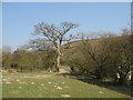
1
Cwm Kesty
Former farmhouse tucked into a dingle in the side of Gwaunceste Hill
Image: © Richard Webb
Taken: 1 Apr 2007
0.01 miles
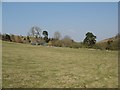
2
Cnwch Bank from Cwm Ceste
Looking east from the byway. Cnwch Bank is the steep western slope of Llanfihangel Hill.
Image: © Graham Horn
Taken: 24 Nov 2008
0.10 miles
3
Gateway, Cwmceste
Look closely at the gateway and there is the remains of a wind felled scots pine tree.
Image: © Richard Webb
Taken: 1 Apr 2007
0.11 miles
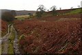
4
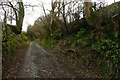
Lane at Cwm Ceste
The lane links a byway to the north with the C road at New Cwmceste. Clearly this white road has public status, but the OS feels it necessary to show the dotted "other routes with public access" symbol.
Image: © Graham Horn
Taken: 24 Nov 2008
0.18 miles
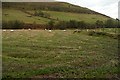
5
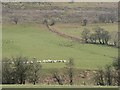
Under Cnwch Bank
The sheep have just been fed by a hopper towed behind a Landrover. The valley was a noisy place when this happened. The ewes bolted for the food, and then the inevitable calling as all the lost lambs and mothers tried to find each other.
Image: © Richard Webb
Taken: 1 Apr 2007
0.19 miles
6
Byway at Blaen Ceste
Looking south from the head of Cwm Ceste on the important north-south byway.
Image: © Graham Horn
Taken: 24 Nov 2008
0.23 miles