IMAGES TAKEN NEAR TO
Gravel Hill Drive, KINGTON, HR5 3AE
Introduction
This page details the photographs taken nearby to Gravel Hill Drive, HR5 3AE by members of the Geograph project.
The Geograph project started in 2005 with the aim of publishing, organising and preserving representative images for every square kilometre of Great Britain, Ireland and the Isle of Man.

There are currently over 7.5m images from over14,400 individuals and you can help contribute to the project by visiting https://www.geograph.org.uk
Image Map
Images are licensed for reuse under creativecommons.org/licenses/by-sa/2.0
Notes
- Clicking on the map will re-center to the selected point.
- The higher the marker number, the further away the image location is from the centre of the postcode.
Image Listing (146 Images Found)
Images are licensed for reuse under creativecommons.org/licenses/by-sa/2.0
Image
Details
Distance
1
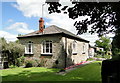
Meredith's Foundry, Sunset, Kington
The former pattern shop, now a delightful private house.
Image: © Philip Pankhurst
Taken: 5 Jul 2010
0.01 miles
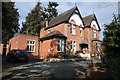
2
Kington Youth Hostel
Kington Youth Hostel on Victoria Road, just east of the town centre.
Image: © Philip Halling
Taken: 23 Feb 2018
0.04 miles
4
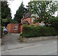
YHA Kington
The YHA (Youth Hostels Association) hostel is in Victoria Road.
Image: © Jaggery
Taken: 26 Jun 2013
0.04 miles
5
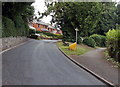
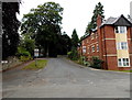
Western end of Gravel Hill Drive, Kington
Viewed from near the corner of Board School Lane. http://www.geograph.org.uk/photo/3536975
The path on the right leads to the route of a former tramway.
Image: © Jaggery
Taken: 26 Jun 2013
0.04 miles
6
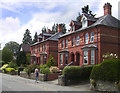
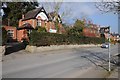
Houses on Victoria Road
A lovely pair of red brick semis on the road between town and the former station.
Image: © Des Blenkinsopp
Taken: 22 Jun 2014
0.04 miles
7
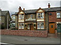
Ye Olde Tavern on the outskirts of Kington
A very traditional looking public house in Kington.
Image: © Phil Catterall
Taken: 11 Aug 2006
0.05 miles
8
Path to former tramway, Kington
The path heads east away from Gravel Hill Drive. http://www.geograph.org.uk/photo/3536990
Image: © Jaggery
Taken: 26 Jun 2013
0.05 miles
9
Gravel Hill Drive, Kington
Gravel Hill Drive climbs away from Victoria Road on the right and Duke Street on the left.
Vaughan Court http://www.geograph.org.uk/photo/3538785 is on the right.
Image: © Jaggery
Taken: 26 Jun 2013
0.07 miles
10
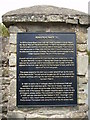
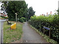
Cast iron information sign
Sited on the old tramway out of Kington this sign explains the history of the old Tramway that ran via Hay on Wye to the Brecon Canal. It is located near to the old Kington railway station. The railway came in 1857 however, passenger traffic ceased in 1955, with freight traffic continuing until 1964, when the line closed.
Image: © Phil Catterall
Taken: 11 Aug 2006
0.07 miles