IMAGES TAKEN NEAR TO
Newtown Road, HEREFORD, HR4 9LH
Introduction
This page details the photographs taken nearby to Newtown Road, HR4 9LH by members of the Geograph project.
The Geograph project started in 2005 with the aim of publishing, organising and preserving representative images for every square kilometre of Great Britain, Ireland and the Isle of Man.

There are currently over 7.5m images from over14,400 individuals and you can help contribute to the project by visiting https://www.geograph.org.uk
Image Map
Images are licensed for reuse under creativecommons.org/licenses/by-sa/2.0
Notes
- Clicking on the map will re-center to the selected point.
- The higher the marker number, the further away the image location is from the centre of the postcode.
Image Listing (214 Images Found)
Images are licensed for reuse under creativecommons.org/licenses/by-sa/2.0
Image
Details
Distance
1

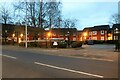
Another out of town shopping centre
This picture could have been taken in any one of dozens of towns or cities from Plymouth to Inverness. No one would know! This one happens to be Hereford.
Image: © Philip Halling
Taken: 24 Jan 2009
0.03 miles
2
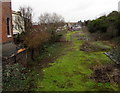
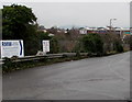
Route of a former canal, Hereford
Looking NW from College Road near Widemarsh Street in January 2016. This was part of the Herefordshire and Gloucestershire Canal (or Hereford and Gloucester Canal) which closed in 1881.
Image: © Jaggery
Taken: 11 Jan 2016
0.04 miles
3
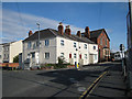
Terrace built in the 1950s
From Widemarsh Street, approaching College Road. The van is driving over Widemarsh Bridge which once crossed the Hereford & Gloucester Canal.
Image: © Pauline E
Taken: 11 Oct 2008
0.05 miles
4
Addison Court on Edgar Street, Hereford
Image: © David Howard
Taken: 3 Feb 2024
0.05 miles
5
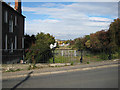
Route of the Hereford & Gloucester Canal behind houses on Newton Road
Image: © Rob Purvis
Taken: 25 Jul 2009
0.06 miles
6
RMW (Recycling Metal & Waste) this way, Hereford
At the College Road junction, a sign points right along
Burcott Road towards RMW, buyers of scrap metal (ferrous or non-ferrous).
Image: © Jaggery
Taken: 11 Jan 2016
0.06 miles
7
Route of former Hereford and Gloucester Canal
Taken from Widemarsh Bridge towards Aylestone. The canal closed in 1883 and the eastern section of the route between Ledbury and Gloucester was turned into a railway. The arch below the bridge is bricked up.
Image: © Pauline E
Taken: 11 Oct 2008
0.06 miles
8
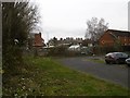
Merton Meadow car park
The bit over the brook. The car park used to be a cheap option but is now very expensive to use.
Image: © Richard Webb
Taken: 28 Dec 2015
0.06 miles
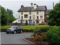
9
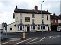
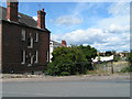
Heart of Oak, Hereford
Pub at 47 Newtown Road, at the northern edge of Edgar Street.
Image: © Jaggery
Taken: 27 Aug 2012
0.06 miles
10
The Heart of Oak, Newtown Road, Hereford
Overlooking the retail park that includes Curry's PC World.
Image: © Jonathan Billinger
Taken: 17 Jun 2018
0.07 miles