IMAGES TAKEN NEAR TO
Grampian Close, HEREFORD, HR4 0TA
Introduction
This page details the photographs taken nearby to Grampian Close, HR4 0TA by members of the Geograph project.
The Geograph project started in 2005 with the aim of publishing, organising and preserving representative images for every square kilometre of Great Britain, Ireland and the Isle of Man.

There are currently over 7.5m images from over14,400 individuals and you can help contribute to the project by visiting https://www.geograph.org.uk
Image Map
Images are licensed for reuse under creativecommons.org/licenses/by-sa/2.0
Notes
- Clicking on the map will re-center to the selected point.
- The higher the marker number, the further away the image location is from the centre of the postcode.
Image Listing (20 Images Found)
Images are licensed for reuse under creativecommons.org/licenses/by-sa/2.0
Image
Details
Distance
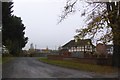
1
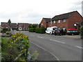
Hillary Drive
Part of a housing estate with roads named after notable mountaineers.
Image: © Peter Whatley
Taken: 29 Jun 2009
0.10 miles
2
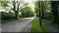
King's Acre Road, looking east
Eight fifteen on a Sunday morning and the joggers are out.
Image: © Jonathan Billinger
Taken: 15 May 2016
0.13 miles
3
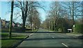
The A438 Road (King's Acre)
The avenue on this road can be a nice welcome to those entering the city of Hereford, although I was actually exiting Hereford when I took this photo.
Image: © Fabian Musto
Taken: 1 Feb 2020
0.13 miles
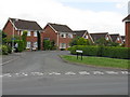
4
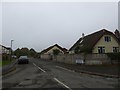
Huntsmans Drive, King's Acre
Access road to a small housing estate
Image: © David Smith
Taken: 19 Oct 2017
0.13 miles
5
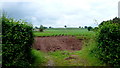
Gap in the hedge, King's Acre Road
Permits a view of potato field and hilltop tree.
See Image taken one month earlier.
Image: © Jonathan Billinger
Taken: 17 Jun 2016
0.14 miles
6
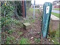
Old Boundary Stone, Kings Acre Road, Hereford
On Herefordshire bridleway BT3 alongside Kings Court and opposite Huntingdon lane.
Inscription: L. / C. H.
Milestone Society National ID: HF_HERBRE02pb
Image: © Mr Red
Taken: 14 Jan 2023
0.14 miles
7
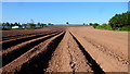
Arable land by Kings Acre Road
This piece of farmland, with potatoes planted, forms an arm of the countryside that breaks up the ribbon development along the A438 to the west of Hereford.
Image: © Jonathan Billinger
Taken: 16 May 2016
0.14 miles
8
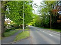
King's Acre Road, looking west
The leafy A438 towards Brecon about 3km from Hereford city centre.
Image: © Jonathan Billinger
Taken: 15 May 2016
0.15 miles
9
Kings Court housing estate
A small development. There is a right of way to Lower Breinton
Image: © David Smith
Taken: 19 Oct 2017
0.16 miles
10
Tensing Close
Part of a housing estate with roads named after notable mountaineers.
Image: © Peter Whatley
Taken: 29 Jun 2009
0.17 miles