IMAGES TAKEN NEAR TO
Trinity Road, HEREFORD, HR4 0RS
Introduction
This page details the photographs taken nearby to Trinity Road, HR4 0RS by members of the Geograph project.
The Geograph project started in 2005 with the aim of publishing, organising and preserving representative images for every square kilometre of Great Britain, Ireland and the Isle of Man.

There are currently over 7.5m images from over14,400 individuals and you can help contribute to the project by visiting https://www.geograph.org.uk
Image Map
Images are licensed for reuse under creativecommons.org/licenses/by-sa/2.0
Notes
- Clicking on the map will re-center to the selected point.
- The higher the marker number, the further away the image location is from the centre of the postcode.
Image Listing (40 Images Found)
Images are licensed for reuse under creativecommons.org/licenses/by-sa/2.0
Image
Details
Distance
1
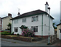
19 Ranelagh Street, Hereford
By Nicholson & Clarke, 1934, hardly betraying its age.
Image: © Stephen Richards
Taken: 23 Jun 2017
0.05 miles
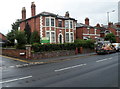
2
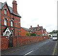
Ranelagh Street, Hereford
Ranelagh Street is a 160 metre long cul-de-sac on the north side of Whitecross Road.
Image: © Jaggery
Taken: 27 Aug 2012
0.05 miles
3
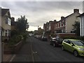
Ranelagh Street, Whitecross
Suburban Hereford, the goto place for c.1900 brick housing on a big scale.
Image: © Richard Webb
Taken: 13 Aug 2019
0.06 miles
4
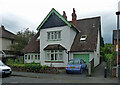
25 Ranelagh Street, Hereford
A latecomer to Arts and Crafts by Bettington & Son, 1931-32.
Image: © Stephen Richards
Taken: 23 Jun 2017
0.06 miles
5
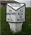
Old Milepost by the A438, Whitecross Road, Hereford Parish
Cast iron post by the A438, in parish of HEREFORD (District), Whitecross Road, opposite No. 227; 50m West of junction with Ranelagh Street, on grassy embankment, on North side of road. Hodges iron T-post, erected by the Hereford turnpike trust in the 19th century.
Inscription reads:- : TO / HEREFORD / 1 / MILE : : HOLMER / PARISH : : TO / HAY / 19 / MILES : : C HODGES / & / SON / HEREFORD / FOUNDRY / 1849. :
Milestone Society National ID: HF_HFHY01
Image: © M Faherty
Taken: 26 Aug 2008
0.07 miles
6
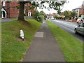
Holmer Parish milepost, Whitecross Road, Hereford
The milepost shows
HOLMER PARISH
TO HEREFORD 1 MILE
TO HAY 19 MILES.
Image: © Jaggery
Taken: 27 Aug 2012
0.07 miles
7
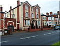
Westfield House, Hereford
The detached house on the south side of Whitecross Road is much larger than adjacent houses.
Image: © Jaggery
Taken: 27 Aug 2012
0.08 miles
8
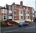
Mid-Victorian villas, Whitecross Road, Hereford
A large tablet between second floor windows shows BRAMPTON VILLAS 1864.
Image: © Jaggery
Taken: 27 Aug 2012
0.08 miles
9
Haywood House Dentistry, Hereford
On the corner of Whitecross Road and Sollars Close.
Image: © Jaggery
Taken: 27 Aug 2012
0.09 miles
10
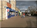
Hereford: Yazor Road Post Office
This post office, within a McColl's general store, opened in December 2016 as a replacement for an office in King's Acre Road, about half a mile away. It is on a parade which swings around the corner of White Cross Road (which it faces) and Yazor Road which heads left just behind the camera - although the address of the shop is actually 2 Yazor Road. The postbox was already outside the parade.
Image: © Chris Downer
Taken: 13 Mar 2017
0.10 miles