IMAGES TAKEN NEAR TO
The Dingle, HEREFORD, HR4 0QU
Introduction
This page details the photographs taken nearby to The Dingle, HR4 0QU by members of the Geograph project.
The Geograph project started in 2005 with the aim of publishing, organising and preserving representative images for every square kilometre of Great Britain, Ireland and the Isle of Man.

There are currently over 7.5m images from over14,400 individuals and you can help contribute to the project by visiting https://www.geograph.org.uk
Image Map
Images are licensed for reuse under creativecommons.org/licenses/by-sa/2.0
Notes
- Clicking on the map will re-center to the selected point.
- The higher the marker number, the further away the image location is from the centre of the postcode.
Image Listing (29 Images Found)
Images are licensed for reuse under creativecommons.org/licenses/by-sa/2.0
Image
Details
Distance
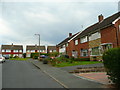
1
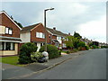
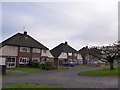
Hewitt Avenue, Kings Acre, Hereford 2
View south at the end where semi-detached gives way to detached.
Image: © Jonathan Billinger
Taken: 28 Jul 2008
0.10 miles
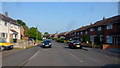
2
Langland Drive, Whitecross, Hereford
Road leading north from Westfaling Street.
Image: © Jonathan Billinger
Taken: 3 Jun 2016
0.10 miles
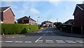
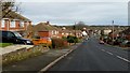
4
Houses set back from A438
Houses with address in Kings Acre Road are set back from the main road
Image: © David Smith
Taken: 19 Oct 2017
0.11 miles
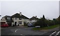
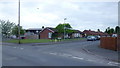
5
Hewitt Avenue, Kings Acre, Hereford 1
Looking east along this cul-de-sac of semi-detached housing.
Image: © Jonathan Billinger
Taken: 28 Jul 2008
0.14 miles
6
Westfaling Street, Hereford
Beyond the roundabout at the top of Wordsworth Road, the road becomes a cul-de-sac leading to a pathway onto open countryside.
Image: © Jonathan Billinger
Taken: 6 Jun 2016
0.14 miles
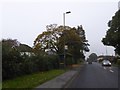
7
Wordsworth Road
Descends from White Cross Hill to the Monument roundabout on the A438 King's Acre Road.
Image: © Jonathan Billinger
Taken: 21 Feb 2016
0.18 miles
8
Marlowe Drive, Hereford
Viewed from Wordsworth Road.
Image: © Jonathan Billinger
Taken: 20 May 2016
0.19 miles
9
Semi-detached houses and service road
Parallel to Three Elms Road
Image: © David Smith
Taken: 29 Nov 2014
0.19 miles
10
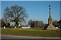
White Cross roundabout, Hereford
The White Cross roundabout is on the A438 road to Brecon at its junction with the A4110. To the east of the cross the A438 is Whitecross Road, to the west it is Kings Acre Road.
White Cross is thought to have been built in 1362 by Bishop Charlton to mark the site of a market place to the west of the city because people where afraid to enter the city due to the plaque. The Black Death which first hit the city of Hereford in 1349 returned claiming more lives in 1361. The six coat of arms around the six sided base of the shaft are that of Bishop Charlton, alternating between a lion rampant and a lion rampant with crosses. The cross underwent restoration in 1864 under Sir George Gilbert Scott, and again in 1992. The cross is Grade II* listed.
Image: © Philip Halling
Taken: 7 Mar 2010
0.19 miles