IMAGES TAKEN NEAR TO
Bridle Road, HEREFORD, HR4 0PW
Introduction
This page details the photographs taken nearby to Bridle Road, HR4 0PW by members of the Geograph project.
The Geograph project started in 2005 with the aim of publishing, organising and preserving representative images for every square kilometre of Great Britain, Ireland and the Isle of Man.

There are currently over 7.5m images from over14,400 individuals and you can help contribute to the project by visiting https://www.geograph.org.uk
Image Map
Images are licensed for reuse under creativecommons.org/licenses/by-sa/2.0
Notes
- Clicking on the map will re-center to the selected point.
- The higher the marker number, the further away the image location is from the centre of the postcode.
Image Listing (15 Images Found)
Images are licensed for reuse under creativecommons.org/licenses/by-sa/2.0
Image
Details
Distance
1
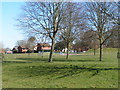
Play area next to Huntsmans Drive, Hereford
Image: © Rob Purvis
Taken: 2 Apr 2013
0.06 miles
2
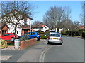
Houses and cars on Huntsmans Drive, Hereford
Image: © Rob Purvis
Taken: 2 Apr 2013
0.08 miles
3
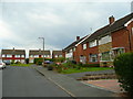
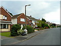
Hewitt Avenue, Kings Acre, Hereford 1
Looking east along this cul-de-sac of semi-detached housing.
Image: © Jonathan Billinger
Taken: 28 Jul 2008
0.10 miles
4
Huntsmans Drive, King's Acre
Access road to a small housing estate
Image: © David Smith
Taken: 19 Oct 2017
0.12 miles
5
Hewitt Avenue, Kings Acre, Hereford 2
View south at the end where semi-detached gives way to detached.
Image: © Jonathan Billinger
Taken: 28 Jul 2008
0.12 miles
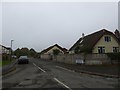
7
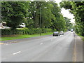
King's Acre Road
The main road to the West, from Hereford.
Image: © Roger Cornfoot
Taken: 26 Dec 2006
0.18 miles
8

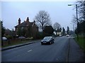
Stephen's Close, Whitecross, Hereford
Viewed from the end of Westfaling Street. Presently the western edge of Hereford's suburbs.
Image: © Jonathan Billinger
Taken: 2 Jun 2016
0.19 miles
9
Gap in the hedge, King's Acre Road
Permits a view of potato field and hilltop tree.
See Image taken one month earlier.
Image: © Jonathan Billinger
Taken: 17 Jun 2016
0.21 miles
10
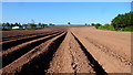
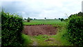
Arable land by Kings Acre Road
This piece of farmland, with potatoes planted, forms an arm of the countryside that breaks up the ribbon development along the A438 to the west of Hereford.
Image: © Jonathan Billinger
Taken: 16 May 2016
0.22 miles