IMAGES TAKEN NEAR TO
Kernal Road, HEREFORD, HR4 0PR
Introduction
This page details the photographs taken nearby to Kernal Road, HR4 0PR by members of the Geograph project.
The Geograph project started in 2005 with the aim of publishing, organising and preserving representative images for every square kilometre of Great Britain, Ireland and the Isle of Man.

There are currently over 7.5m images from over14,400 individuals and you can help contribute to the project by visiting https://www.geograph.org.uk
Image Map
Images are licensed for reuse under creativecommons.org/licenses/by-sa/2.0
Notes
- Clicking on the map will re-center to the selected point.
- The higher the marker number, the further away the image location is from the centre of the postcode.
Image Listing (138 Images Found)
Images are licensed for reuse under creativecommons.org/licenses/by-sa/2.0
Image
Details
Distance
1
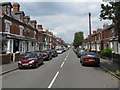
Ryelands Street
Part of a large area of housing developed in the 1880s and 1890s, with most houses bearing an individual date stone. Well worth exploring.
Image: © Peter Whatley
Taken: 29 Jun 2009
0.03 miles

3
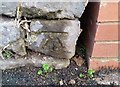
Ordnance Survey Cut Mark
This OS cut mark can be found on the wall of No60 Ryelands Street. It marks a point 57.339m above mean sea level.
Image: © Adrian Dust
Taken: 10 Mar 2019
0.06 miles
4
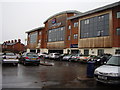
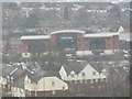
Hereford, Travelodge
Whilst not containing restaurant facilities there are plenty of places to eat within walking distance.
Or of course there is Sainsbury's next door.
Image: © Anthony Vosper
Taken: 4 Mar 2012
0.06 miles
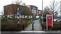
5
Cycle and foot crossing, Sainsbury's car park, Hereford
Beyond the path is the Hereford Travelodge
Image: © David Smith
Taken: 29 Nov 2014
0.06 miles
6
Travelodge (Hereford)
Here is Travelodge, viewed from the bell tower at Hereford Cathedral. Sainsbury's was blocked out by some buildings nearby to Travelodge.
Image: © Fabian Musto
Taken: 7 Apr 2018
0.07 miles
7
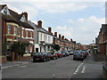
Hereford Street Scene (2)
Taken at the junction with Stanhope Road. Part of a large area of housing developed in the 1880s and 1890s, with most houses bearing an individual date stone. Well worth exploring.
Image: © Peter Whatley
Taken: 29 Jun 2009
0.07 miles
8
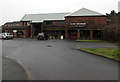
Hereford Cider Museum & King Offa Distillery, Hereford
Located in Pomona Place. The Cider Museum is in a former cider making factory. Visitors can explore original champagne cider cellars and view cidermaking equipment, a cooper's workshop and a vat house. King Offa Distillery produces various ciders and cider-based fruit liqueurs.
Image: © Jaggery
Taken: 30 Jan 2017
0.07 miles
9
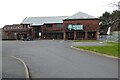
Museum of Cider
Museum of Cider in Hereford.
Image: © Philip Halling
Taken: 15 Mar 2022
0.07 miles
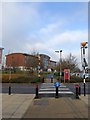
10
Public path
An urban footpath and cycleway that traverses Sainsbury's car park in the direction of the Travelodge.
Image: © Jonathan Billinger
Taken: 6 Jan 2018
0.08 miles