IMAGES TAKEN NEAR TO
Belvedere Lane, HEREFORD, HR4 0PH
Introduction
This page details the photographs taken nearby to Belvedere Lane, HR4 0PH by members of the Geograph project.
The Geograph project started in 2005 with the aim of publishing, organising and preserving representative images for every square kilometre of Great Britain, Ireland and the Isle of Man.

There are currently over 7.5m images from over14,400 individuals and you can help contribute to the project by visiting https://www.geograph.org.uk
Image Map
Images are licensed for reuse under creativecommons.org/licenses/by-sa/2.0
Notes
- Clicking on the map will re-center to the selected point.
- The higher the marker number, the further away the image location is from the centre of the postcode.
Image Listing (97 Images Found)
Images are licensed for reuse under creativecommons.org/licenses/by-sa/2.0
Image
Details
Distance
1
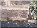
Ordnance Survey Cut Mark
This OS cut mark can be found on the gatepost of No24 Broomy Hill. It marks a point 55.056m above mean sea level.
Image: © Adrian Dust
Taken: 10 Mar 2019
0.03 miles
2
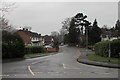
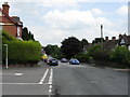
Broomy Hill, Hereford
Ahead, the road named Broomy Hill leads to the Broomy Hill area of Hereford.
Barton Road is in the foreground on the left. Breinton Road is on the right.
Image: © Jaggery
Taken: 30 Jan 2017
0.05 miles
3
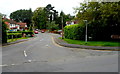
Broomy Hill, Hereford
Viewed from Barton Road. A brown sign on the right points along Broomy Hill towards the Waterworks Museum.
Image: © Jaggery
Taken: 27 Aug 2012
0.05 miles
4
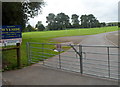
Wyeside entrance, Hereford
This is the Belvedere Lane entrance to Hereford Cathedral School sports ground,
on the north bank of the River Wye.
Image: © Jaggery
Taken: 27 Aug 2012
0.07 miles
5
Ordnance Survey Cut Mark
This OS cut mark can be found on No31 Broomy Hill. It marks a point 59.470m above mean sea level.
Image: © Adrian Dust
Taken: 10 Mar 2019
0.07 miles
6
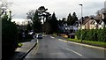
Broomy Hill Road
Minor road leading west out of Hereford through quiet suburbs.
Image: © Jonathan Billinger
Taken: 12 Jan 2016
0.07 miles
7
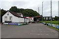
Clubhouse, Hereford Rugby Club
The clubhouse is in the SW corner of the rugby club's ground on the north bank of the River Wye, near Belvedere Lane.
Image: © Jaggery
Taken: 27 Aug 2012
0.09 miles
9
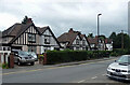
15-25 Breinton Road, Hereford
Typical half-timbered jobs by Bettington & Son from the 1920s/1930s.
Image: © Stephen Richards
Taken: 23 Jun 2017
0.10 miles
10
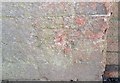
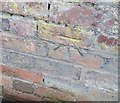
Ordnance Survey Cut Mark
This badly eroded OS cut mark can be found on the wall south side of Breinton Road. It marks a point 57.022m above mean sea level.
Image: © Adrian Dust
Taken: 10 Mar 2019
0.10 miles