IMAGES TAKEN NEAR TO
Sweet Chestnut Drive, HEREFORD, HR4 0FJ
Introduction
This page details the photographs taken nearby to Sweet Chestnut Drive, HR4 0FJ by members of the Geograph project.
The Geograph project started in 2005 with the aim of publishing, organising and preserving representative images for every square kilometre of Great Britain, Ireland and the Isle of Man.

There are currently over 7.5m images from over14,400 individuals and you can help contribute to the project by visiting https://www.geograph.org.uk
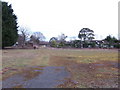
Image Map
Images are licensed for reuse under creativecommons.org/licenses/by-sa/2.0
Notes
- Clicking on the map will re-center to the selected point.
- The higher the marker number, the further away the image location is from the centre of the postcode.
Image Listing (14 Images Found)
Images are licensed for reuse under creativecommons.org/licenses/by-sa/2.0
Image
Details
Distance
1
Abandoned nursery at Swainshill
It's a few years since these glasshouses produced a crop. This place is less than half a mile from the huge Wyevale Nurseries, and Garden Centre on the King's Acre Road. 3000.
Image: © Jonathan Billinger
Taken: 12 Mar 2007
0.08 miles
2
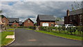
New housing with private road
This is Breinton Leyse, developed on the site of the old nursery photographed 12 years earlier, see Image
Image: © Jonathan Billinger
Taken: 20 Jun 2019
0.08 miles
5
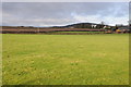
Farmland at Swainshill
Farmland at Swainshill to the south of the A438.
Image: © Philip Halling
Taken: 21 Dec 2011
0.13 miles
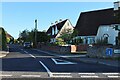
6
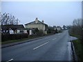
Swainshill
The road from Hereford to Brecon.
Image: © Roger Cornfoot
Taken: 26 Dec 2006
0.15 miles
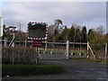
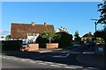
8
A480 heading north past Wyevale Business Park
Image: © Rob Purvis
Taken: 26 Dec 2009
0.20 miles
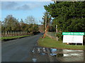
9
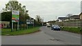
A480 Kington Road
Looking towards the junction with A438 Kings Acre Road, by the exit from Wyevale Garden Centre.
Image: © Jonathan Billinger
Taken: 19 Apr 2016
0.21 miles
10
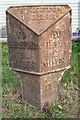
Old Milepost by the A438, Swainshill, Stretton Sugwas parish
Cast iron post by the A438, in parish of STRETTON SUGWAS (District), Swainshill, on verge near greenhouse. Hereford iron T-post, erected by the Hereford turnpike trust in the 19th century.
Inscription reads:-
: TO / HEREFORD / 3 / MILES : : STRETTON / PARISH : : TO / HAY / 17 / MILES :
Herefordshire SMR.
SMR Number: 56613 https://www.heritagegateway.org.uk/Gateway/Results_Single.aspx?uid=MHE28369&resourceID=101
Milestone Society National ID: HF_HFHY03.
Image: © Robert Walker
Taken: 30 Oct 2011
0.21 miles