IMAGES TAKEN NEAR TO
Brilley, Whitney-on-Wye, HEREFORD, HR3 6JR
Introduction
This page details the photographs taken nearby to HR3 6JR by members of the Geograph project.
The Geograph project started in 2005 with the aim of publishing, organising and preserving representative images for every square kilometre of Great Britain, Ireland and the Isle of Man.

There are currently over 7.5m images from over14,400 individuals and you can help contribute to the project by visiting https://www.geograph.org.uk
Image Map
Images are licensed for reuse under creativecommons.org/licenses/by-sa/2.0
Notes
- Clicking on the map will re-center to the selected point.
- The higher the marker number, the further away the image location is from the centre of the postcode.
Image Listing (6 Images Found)
Images are licensed for reuse under creativecommons.org/licenses/by-sa/2.0
Image
Details
Distance
1
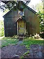
Former Tin Methodist Chapel at Brilley Mountain
Image: © paul wood
Taken: 23 Sep 2003
0.12 miles
2
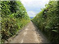
A very narrow road
Descending between steep hedgerows from Brilley Mountain.
Image: © Richard Webb
Taken: 29 Jun 2014
0.14 miles
3

Footpath sign, Brilley Mountain
I had passed west of the edge of my map, so was interested to see the Powys County Council path sign. The road is the Herefordshire/Radnorshire boundary.
Image: © Richard Webb
Taken: 29 Jun 2014
0.21 miles
4
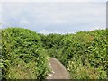
A very narrow road
A road, somewhat overgrown in places, descends from Brilley Mountain.
Image: © Richard Webb
Taken: 29 Jun 2014
0.23 miles
5
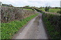
Road to Brilley Mountain
Narrow country road to Brilley Mountain on the Herefordshire and Powys border.
Image: © Philip Halling
Taken: 5 May 2012
0.24 miles
6
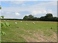
Sheep, Perryn
A rare chance of seeing out of the steep sided, high hedged narrow road which descends from Brilley Mountain.
Image: © Richard Webb
Taken: 29 Jun 2014
0.24 miles