IMAGES TAKEN NEAR TO
Dorstone, HEREFORD, HR3 6AR
Introduction
This page details the photographs taken nearby to HR3 6AR by members of the Geograph project.
The Geograph project started in 2005 with the aim of publishing, organising and preserving representative images for every square kilometre of Great Britain, Ireland and the Isle of Man.

There are currently over 7.5m images from over14,400 individuals and you can help contribute to the project by visiting https://www.geograph.org.uk
Image Map
Images are licensed for reuse under creativecommons.org/licenses/by-sa/2.0
Notes
- Clicking on the map will re-center to the selected point.
- The higher the marker number, the further away the image location is from the centre of the postcode.
Image Listing (125 Images Found)
Images are licensed for reuse under creativecommons.org/licenses/by-sa/2.0
Image
Details
Distance
1

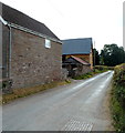
Barn near Dorstone Court, Dorstone
Dorstone Court is a potato grading station. http://www.geograph.org.uk/photo/3704157
Image: © Jaggery
Taken: 16 Sep 2012
0.02 miles
2

Upper tributary of the River Dore
At Dorstone, Herefordshire.
Image: © Jonathan Billinger
Taken: 9 Jun 2010
0.03 miles
3

Brook with a Welsh name in English Dorstone
Viewed from Jubilee Bridge in Dorstone, Herefordshire. Pont-y-Weston Brook flows into the River Dore about 250 metres behind the camera.
Image: © Jaggery
Taken: 16 Sep 2012
0.04 miles
4
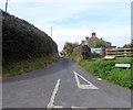
An unnamed road passes Bridge Cottage, Dorstone
Several roads in the village are unnamed.
This one is viewed from the edge of the B4348 looking south past Bridge Cottage.
Image: © Jaggery
Taken: 16 Sep 2012
0.08 miles
5

Entrance road to Dorstone Court, Dorstone
Dorstone Court is the premises of J.G.Goring Ltd, potato merchants.
Image: © Jaggery
Taken: 16 Sep 2012
0.09 miles
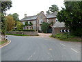
6
Chapel Lane, Dorstone
Chapel Lane is one of the few named streets in the village. Viewed looking WNW from one of the unnamed streets.
Image: © Jaggery
Taken: 16 Sep 2012
0.09 miles
8

Potato Grading Station in Dorstone Court, Dorstone
Dorstone Court is the premises of J.G.Goring Ltd, potato merchants.
Image: © Jaggery
Taken: 16 Sep 2012
0.10 miles
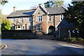
9
Grade II listed The Court House, Dorstone
Located facing a sharp bend in the B4348, the detached house is of two periods. The northern half dates from the 18th century. The southern half is Edwardian (early 20th century).
Grade II listed in February 1993.
Image: © Jaggery
Taken: 16 Sep 2012
0.10 miles
10
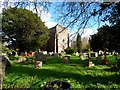
St Faith's church, Dorstone
This church was built in 1889. There have been three churches on this site. The first was built in 1256 by the family of one of the killers (Richard de Brito) of Thomas a Becket. The second church was built in 1827 and was replaced by this structure.
Image: © Bikeboy
Taken: 8 Apr 2014
0.11 miles