IMAGES TAKEN NEAR TO
Castle View, HEREFORD, HR3 5SZ
Introduction
This page details the photographs taken nearby to Castle View, HR3 5SZ by members of the Geograph project.
The Geograph project started in 2005 with the aim of publishing, organising and preserving representative images for every square kilometre of Great Britain, Ireland and the Isle of Man.

There are currently over 7.5m images from over14,400 individuals and you can help contribute to the project by visiting https://www.geograph.org.uk
Image Map
Images are licensed for reuse under creativecommons.org/licenses/by-sa/2.0
Notes
- Clicking on the map will re-center to the selected point.
- The higher the marker number, the further away the image location is from the centre of the postcode.
Image Listing (82 Images Found)
Images are licensed for reuse under creativecommons.org/licenses/by-sa/2.0
Image
Details
Distance
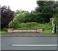
1
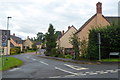
Buttercup Meadow houses, Clyro
Viewed across the A438.
Image: © Jaggery
Taken: 19 Aug 2012
0.06 miles
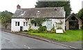
2
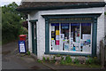
Clyro Post Office
The village post office and stores stand close to Ashbrook House where the well-known diarist, Francis Kilvert, lodged in the 19th century.
Image: © Stephen McKay
Taken: 24 Jul 2009
0.10 miles
3
Cottage adjoining the village stores and post office, Clyro
The single-storey village stores and post office http://www.geograph.org.uk/photo/3091976 can be seen at the far end of the cottage.
Image: © Jaggery
Taken: 19 Aug 2012
0.10 miles
4
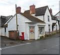
Bridge Stores and post office, Clyro
The absence of the usual red Post Office sign made me think that the post office had been removed.
Proof that it was still in place was a Post Office notice in the window stating that (in common with other post offices) this post office would be not be open on the bank holiday on Monday, August 27th 2012.
Image: © Jaggery
Taken: 19 Aug 2012
0.10 miles
5
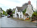
Cottage and lych gate, Clyro
The cottage, address 19 The Village, is alongside the lych gate at the eastern corner of the village churchyard. The lych gate was formerly used to shelter a coffin until the clergyman's arrival for the burial, or pre-burial service.
Image: © Jaggery
Taken: 19 Aug 2012
0.10 miles
6
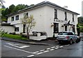
Baskerville Arms, Clyro
The village pub and hotel was previously named the Swan.
See http://www.geograph.org.uk/photo/1418999 for another view, and a description.
Image: © Jaggery
Taken: 19 Aug 2012
0.10 miles
7
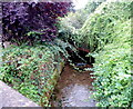
Clyro Brook, Clyro
A tributary of the River Wye, Clyro Brook emerges from a culvert and flows under the A438 near the residential street Buttercup Meadow.
Image: © Jaggery
Taken: 19 Aug 2012
0.10 miles
8
Clyro Brook bridge, Clyro
The bridge carries the A438 over Clyro Brook. http://www.geograph.org.uk/photo/3092230 The year 1959 is inscribed on the bridge wall.
Image: © Jaggery
Taken: 19 Aug 2012
0.10 miles
9
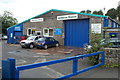
Ashbrook Garage, Clyro
Located opposite the village church. http://www.geograph.org.uk/photo/3091887
Image: © Jaggery
Taken: 19 Aug 2012
0.10 miles
10
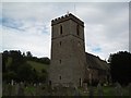
Clyro: St Michael and All Angels
According to the Church Noticeboard, the diarist Francis Kilvert was Curate at this church 1865 - 1872
Image: © Keith Salvesen
Taken: 23 Sep 2009
0.11 miles