IMAGES TAKEN NEAR TO
Glasbury, HEREFORD, HR3 5PD
Introduction
This page details the photographs taken nearby to HR3 5PD by members of the Geograph project.
The Geograph project started in 2005 with the aim of publishing, organising and preserving representative images for every square kilometre of Great Britain, Ireland and the Isle of Man.

There are currently over 7.5m images from over14,400 individuals and you can help contribute to the project by visiting https://www.geograph.org.uk
Image Map
Images are licensed for reuse under creativecommons.org/licenses/by-sa/2.0
Notes
- Clicking on the map will re-center to the selected point.
- The higher the marker number, the further away the image location is from the centre of the postcode.
Image Listing (61 Images Found)
Images are licensed for reuse under creativecommons.org/licenses/by-sa/2.0
Image
Details
Distance
1
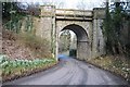
Railway bridge at Glasbury
This railway bridge at Glasbury appears to be still in good order, despite the Hay to Brecon railway it carried closing more than fifty years ago in 1962.
Image: © Philip Halling
Taken: 2 Mar 2015
0.01 miles
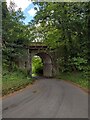
3
Grade II listed Treble Hill railway bridge, Glasbury, viewed from the SE
Built in 1864 for the Hereford, Hay & Brecon Railway, located near the site of the former Glasbury-on-Wye railway station. Passenger services on the route ceased in 1962. The identification on the bridge is BRB HYB 78. It was Grade II listed in December 1995.
http://www.geograph.org.uk/photo/2596554 to a view from the other side.
Image: © Jaggery
Taken: 11 Sep 2011
0.03 miles
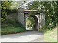
4
Grade II listed Treble Hill railway bridge, Glasbury, viewed from the NW
Built in 1864 for the Hereford, Hay & Brecon Railway, located near the site of the former Glasbury-on-Wye railway station. Passenger services on the route ceased in 1962. The identification on the bridge is BRB HYB 78. It was Grade II listed in December 1995.
http://www.geograph.org.uk/photo/2596558 to a view from the other side.
Image: © Jaggery
Taken: 11 Sep 2011
0.03 miles
5
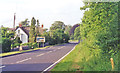
NE on A438 near site of former Glasbury-on-Wye station
The ex-Midland line from Brecon via Three Cocks Junction to Hay-on-Wye and Hereford paralleled the road here until it was closed completely from 31/12/62, the station having been on the right behind the trees.
Image: © Ben Brooksbank
Taken: 13 Jun 1994
0.07 miles
6
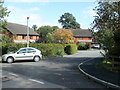
Twin Oaks, Glasbury
A cul-de-sac of modern houses, located about 200 metres SE of the A438, near a Grade II listed disused railway bridge. http://www.geograph.org.uk/photo/2596558
Image: © Jaggery
Taken: 11 Sep 2011
0.08 miles
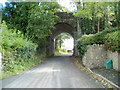
7
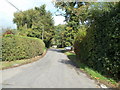
Road from Felindre to Glasbury
The unnamed road from Felindre heads towards the A438. In the middle distance, a car is parked at the edge of a cul-de-sac, Twin Oaks. http://www.geograph.org.uk/photo/2596580 Ahead, the road bends to the left on the approach to a Grade II listed disused railway bridge. http://www.geograph.org.uk/photo/2596558
Image: © Jaggery
Taken: 11 Sep 2011
0.08 miles
8
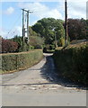
Road from Glasbury to Tir-uched Farm
Viewed from a crossroads of minor roads about 200 metres east of the A438.
An unnamed road heads away from Glasbury, towards Tir-uched Farm and points further east.
Image: © Jaggery
Taken: 11 Sep 2011
0.09 miles
9
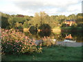
River Wye at Glasbury
Looking south-east across the river as evening sun strikes the extensive Himalayan Balsam. This plant looks attractive, but is a very intrusive weed which has spread widely along the banks.
Image: © Trevor Rickard
Taken: 24 Aug 2007
0.10 miles
10
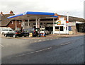
Glasbury Service Station and Post Office
Located on the corner of the A438 and B4350, on the east bank of the River Wye.
The post office opening hours (early September 2011) were 9am to 1pm Monday-Friday, 10am - 12 noon Saturday.
Image: © Jaggery
Taken: 11 Sep 2011
0.11 miles