IMAGES TAKEN NEAR TO
Clyro, HEREFORD, HR3 5JP
Introduction
This page details the photographs taken nearby to HR3 5JP by members of the Geograph project.
The Geograph project started in 2005 with the aim of publishing, organising and preserving representative images for every square kilometre of Great Britain, Ireland and the Isle of Man.

There are currently over 7.5m images from over14,400 individuals and you can help contribute to the project by visiting https://www.geograph.org.uk
Image Map (Loading...)


Getting Data...Please wait
Leaflet Map data © OpenStreetMap
Images are licensed for reuse under creativecommons.org/licenses/by-sa/2.0
Notes
- Clicking on the map will re-center to the selected point.
- The higher the marker number, the further away the image location is from the centre of the postcode.
Image Listing (2 Images Found)
Images are licensed for reuse under creativecommons.org/licenses/by-sa/2.0
Image
Details
Distance
1
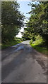
Minor country road
The road begins a steady climb.
Image: © Peter Mackenzie
Taken: 6 Aug 2019
0.11 miles
2
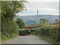
Downhill towards Clyro
The Painscastle to Clyro road passing a property as it heads downhill. The northern edge of the Black Mountains in the distance.
Image: © Gordon Hatton
Taken: 18 Sep 2022
0.25 miles