IMAGES TAKEN NEAR TO
Llancloudy, HEREFORD, HR2 8QW
Introduction
This page details the photographs taken nearby to HR2 8QW by members of the Geograph project.
The Geograph project started in 2005 with the aim of publishing, organising and preserving representative images for every square kilometre of Great Britain, Ireland and the Isle of Man.

There are currently over 7.5m images from over14,400 individuals and you can help contribute to the project by visiting https://www.geograph.org.uk
Image Map
Images are licensed for reuse under creativecommons.org/licenses/by-sa/2.0
Notes
- Clicking on the map will re-center to the selected point.
- The higher the marker number, the further away the image location is from the centre of the postcode.
Image Listing (31 Images Found)
Images are licensed for reuse under creativecommons.org/licenses/by-sa/2.0
Image
Details
Distance
1
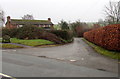
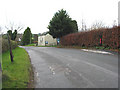
Minor road towards Park Farm, Llancloudy
Viewed across the A466. The bench on the left http://www.geograph.org.uk/photo/4301147 is at a bus stop.
Image: © Jaggery
Taken: 4 Jan 2015
0.02 miles
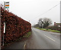
2
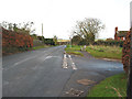
Minor road to Llangarron off the A466 at Llancloudy
With bus stop and handy bench.
A phonebox is marked on the map nearby but no longer exists.
Image: © Pauline E
Taken: 28 Nov 2007
0.03 miles
3
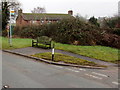
Bus stop bench in Llancloudy
Viewed across the A466. The bus stop sign shows Hill View Llancloudy.
This side for buses towards Monmouth. Signal clearly for bus to stop.
Image: © Jaggery
Taken: 4 Jan 2015
0.05 miles
4
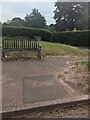
Wooden bench, Llancloudy, Herefordshire
Set back from the east side of the A466 near a bus stop.
Image: © Jaggery
Taken: 18 Jun 2023
0.05 miles
5
Postbox on the A466 at Llancloudy
Towards Monmouth, near the tiny Methodist Church.
Image: © Pauline E
Taken: 28 Nov 2007
0.05 miles
6
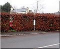
Postbox in a hedge, Llancloudy
On the west side of the A466, alongside a bus stop. http://www.geograph.org.uk/photo/4301177 Viewed in early January 2015. Regular trimming is needed in the warmer months to prevent the postbox being surrounded by the hedge.
Image: © Jaggery
Taken: 4 Jan 2015
0.06 miles
7
Bus stop pole in a hedge, Llancloudy
Alongside the A466 in rural south Herefordshire. This side for buses towards Hereford.
The stop near a bench on the right is for buses towards Monmouth.
Image: © Jaggery
Taken: 4 Jan 2015
0.06 miles
8

Staggered crossroads ahead, Llancloudy
The triangular sign is alongside the A466 in the north of Llancloudy in rural south Herefordshire.
Image: © Jaggery
Taken: 4 Jan 2015
0.06 miles
9
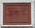
Early Victorian church date stone, Llancloudy
Dated 1840, the inscription is on this http://www.geograph.org.uk/photo/4301190 church
Image: © Jaggery
Taken: 4 Jan 2015
0.07 miles
10
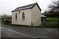
Llancloudy Methodist Church
Viewed across the A466 on a Sunday morning in early January 2015. Although the inscription http://www.geograph.org.uk/photo/4301192 between the windows is PROVIDENCE CHAPEL ERECTED BY JOSEPH MEADMORE 1840, there is no church nameboard here, and a noticeboard at the entrance shows LLANGARRON PARISH COUNCIL.
I was wondering whether this was still a place of worship when several cars arrived with people who entered the church for the 11am service.
Image: © Jaggery
Taken: 4 Jan 2015
0.07 miles