IMAGES TAKEN NEAR TO
Harewood End, HEREFORD, HR2 8JR
Introduction
This page details the photographs taken nearby to HR2 8JR by members of the Geograph project.
The Geograph project started in 2005 with the aim of publishing, organising and preserving representative images for every square kilometre of Great Britain, Ireland and the Isle of Man.

There are currently over 7.5m images from over14,400 individuals and you can help contribute to the project by visiting https://www.geograph.org.uk
Image Map
Images are licensed for reuse under creativecommons.org/licenses/by-sa/2.0
Notes
- Clicking on the map will re-center to the selected point.
- The higher the marker number, the further away the image location is from the centre of the postcode.
Image Listing (24 Images Found)
Images are licensed for reuse under creativecommons.org/licenses/by-sa/2.0
Image
Details
Distance
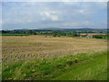
1
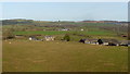
Elvastone Farm, 2019
The arable land use of the early photos for this square has made way for sheep pasture. See Image
Image: © Jonathan Billinger
Taken: 9 Jan 2019
0.03 miles
2
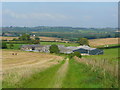
Elvastone Farm
Viewed from the public footpath which leads north from the A49 towards Little Dewchurch.
Image: © Jonathan Billinger
Taken: 24 Sep 2008
0.06 miles
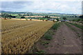
3
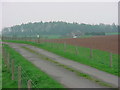
Harewood End - Drive to "Elvastone" from the A49
"Elvastone" is the dwelling in the distance.
Image: © Tony Bailey
Taken: 24 Apr 2006
0.06 miles
4
One bale left
Field near Elvastone Farm, harvested with just one bale of straw left for collection.
Image: © Pauline E
Taken: 16 Oct 2008
0.08 miles
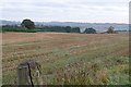
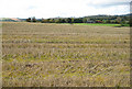
5
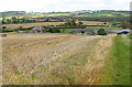
Stubble field south of Elvastone
Looking north towards Aconbury Hill in the distance.
Image: © Jonathan Billinger
Taken: 24 Sep 2008
0.09 miles
6
Harvested wheatfield and Elvaston Farm
Round straw bales in a harvested wheatfield with Elvaston Farm in the middle distance.
Image: © Philip Halling
Taken: 3 Aug 2013
0.09 miles
7
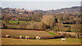
Sheep pasture at Elvastone
Looking north towards the hills and woodland around Little Birch.
Image: © Jonathan Billinger
Taken: 9 Jan 2019
0.12 miles
8
Farmland at Elvastone
Taken from the gateway on the drive to the farm, which is just in the square, looking north-east. The western part of the square is mainly arable fields.
Image: © Graham Horn
Taken: 6 Oct 2008
0.15 miles
9
Field of stubble
Looking towards Llandinabo. The tiny church is hidden in the trees but is in the centre, left of the grey barn.
Image: © Pauline E
Taken: 16 Oct 2008
0.15 miles
10
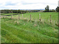
Green pastures
The wide, green footpath in front of the fence borders an arable field; across the fence a pasture. Looking towards Ring Grove.
Image: © Pauline E
Taken: 16 Oct 2008
0.16 miles