IMAGES TAKEN NEAR TO
Bullinghope, HEREFORD, HR2 8EB
Introduction
This page details the photographs taken nearby to HR2 8EB by members of the Geograph project.
The Geograph project started in 2005 with the aim of publishing, organising and preserving representative images for every square kilometre of Great Britain, Ireland and the Isle of Man.

There are currently over 7.5m images from over14,400 individuals and you can help contribute to the project by visiting https://www.geograph.org.uk
Image Map
Images are licensed for reuse under creativecommons.org/licenses/by-sa/2.0
Notes
- Clicking on the map will re-center to the selected point.
- The higher the marker number, the further away the image location is from the centre of the postcode.
Image Listing (45 Images Found)
Images are licensed for reuse under creativecommons.org/licenses/by-sa/2.0
Image
Details
Distance
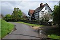
1
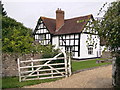
Bullinghope House
Charming L-shaped timber framed house coming up for 400 years old. Clearly, they don't shut the gate.
Image: © Philip Pankhurst
Taken: 9 Sep 2012
0.01 miles
4
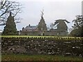
The old church at Bullinghope
The ruins of the medieval church to St. Peter from a country lane to the south, with the Old Vicarage in the background (the ruins are situated on their private gardens). The building dates from around the twelfth century, and this fell into disuse when the new church was built to the west in 1880.
Image: © Fabian Musto
Taken: 25 Oct 2023
0.04 miles
5
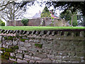
Remains of St Peter's Church, Bullinghope
It's replacement, built around 1880 can be seen here Image
The old church is marked on the 1888 map, scale 1:10,560, as "St Peter's Church, Remains of."
Modern maps make it difficult to see that the two buildings are in different grid squares.
Image: © Pauline E
Taken: 14 Feb 2009
0.04 miles
6
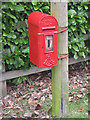
Edward VII letter box, Bullinghope
Lamp box design - first came into use in late Victorian times. This one is later, carrying the Edward VII royal cipher.
Image: © Pauline E
Taken: 14 Feb 2009
0.04 miles
7
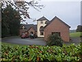
Bullinghope Court
Here is Bullinghope Court from a country lane to the north, built around the late twentieth century on the site of an old gravel pit.
Image: © Fabian Musto
Taken: 25 Oct 2023
0.04 miles
8
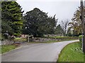
Lane at Bullinghope
This view facing east shows the old vicarage and ruins of the medieval church.
Image: © Fabian Musto
Taken: 25 Oct 2023
0.05 miles
9
Cottage in Bullinghope
Country road passing a cottage in Bullinghope.
Image: © Philip Halling
Taken: 26 Apr 2014
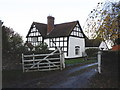
0.07 miles
10

Church House, Bullinghope
A 17th century box frame, extended and re-roofed in the early 19th century, I guess. A beautiful house in a delightful, if windy, rural location, but for how much longer as Hereford threatens to encroach.
Image: © Philip Pankhurst
Taken: 9 Sep 2012
0.07 miles