IMAGES TAKEN NEAR TO
Oulton Avenue, HEREFORD, HR2 7YX
Introduction
This page details the photographs taken nearby to Oulton Avenue, HR2 7YX by members of the Geograph project.
The Geograph project started in 2005 with the aim of publishing, organising and preserving representative images for every square kilometre of Great Britain, Ireland and the Isle of Man.

There are currently over 7.5m images from over14,400 individuals and you can help contribute to the project by visiting https://www.geograph.org.uk
Image Map
Images are licensed for reuse under creativecommons.org/licenses/by-sa/2.0
Notes
- Clicking on the map will re-center to the selected point.
- The higher the marker number, the further away the image location is from the centre of the postcode.
Image Listing (6 Images Found)
Images are licensed for reuse under creativecommons.org/licenses/by-sa/2.0
Image
Details
Distance
1
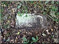
Milestone, Belmont Road, Hereford
A damaged milestone lying on its back. Technically in the parish of Clehonger, on the SW side of the road.
This MS was upright and sunken until after 20th April 2013 see https://www.bench-marks.org.uk/bm48206
Inscription: To / Hereford / 2 Miles
Milestone Society National ID: HF_HFAG02
Image: © Mr Red
Taken: 4 Oct 2023
0.09 miles
2
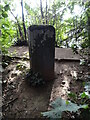
Old Boundary Marker in Belmont Haywood Country Park
Municipal Boundary Marker on the east dam wall of Belmont Pool in Belmont Haywood Country Park. On the boundary of Clehonger and Hereford St Martin parishes until 1932, and since then Clehonger and Hereford parishes. The inscription L / C H represents Liberties of the City of Hereford.
Milestone Society National ID: HF_HERCLE01pb
Image: © Roadside Relics
Taken: 7 Aug 2023
0.18 miles
3
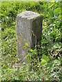
Old Boundary Marker in Belmont Haywood Country Park
Municipal Boundary Marker on the south shore of Belmont Pool in Belmont Haywood Country Park. On the boundary of Clehonger and Hereford St Martin parishes, then Haywood and Hereford St Martin parishes until 1932, and since then Haywood and Hereford parishes. The inscription represents Liberties of the City of Hereford.
Milestone Society National ID: HF_HAYHER02pb
Image: © Roadside Relics
Taken: 7 Aug 2023
0.19 miles
4
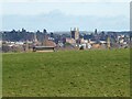
View to Hereford Cathedral
View to Hereford Cathedral, with the spire of All Saints church to the left viewed from opposite Belmont Abbey. In the field is a sheep rack which is used for feeding hay and nuts to sheep.
Image: © Philip Halling
Taken: 1 Feb 2022
0.22 miles
5
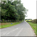
Ruckhall Lane, Belmont
Rucknall Lane heads away from the A465 in Belmont. Nearby signs show that Ruckhall is 2½ miles away. This is also the road to Belmont golf course.
Image: © Jaggery
Taken: 26 Aug 2012
0.24 miles