IMAGES TAKEN NEAR TO
Fern Bank, HEREFORD, HR2 0TZ
Introduction
This page details the photographs taken nearby to Fern Bank, HR2 0TZ by members of the Geograph project.
The Geograph project started in 2005 with the aim of publishing, organising and preserving representative images for every square kilometre of Great Britain, Ireland and the Isle of Man.

There are currently over 7.5m images from over14,400 individuals and you can help contribute to the project by visiting https://www.geograph.org.uk
Image Map
Images are licensed for reuse under creativecommons.org/licenses/by-sa/2.0
Notes
- Clicking on the map will re-center to the selected point.
- The higher the marker number, the further away the image location is from the centre of the postcode.
Image Listing (190 Images Found)
Images are licensed for reuse under creativecommons.org/licenses/by-sa/2.0
Image
Details
Distance
1
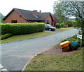
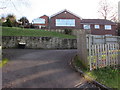
Fern Bank, Ewyas Harold
Viewed from Dark Lane. Fern Bank is short cul-de-sac.
Image: © Jaggery
Taken: 9 Sep 2011
0.03 miles
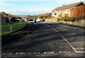
2
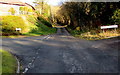
Crossroads in Ewyas Harold
Dark Lane is behind the camera and ahead.
The Fern Bank junction is on the left.
The Glebe Close junction is on the right.
Image: © Jaggery
Taken: 3 Dec 2017
0.04 miles
3
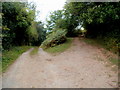
A fork in the track, Ewyas Harold Common
Ewyas Harold Common covers an area of 50 hectares on a plateau above Herefordshire's Golden Valley. Its highest point is 164 metres (c538 feet) above mean sea level.
Image: © Jaggery
Taken: 9 Sep 2011
0.05 miles
4
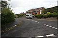
Vicarage Close
Part of the expansion of Ewyas Harold, with a considerable number of bungalows, suggesting retired people were driving the expansion.
Image: © Hugh Venables
Taken: 13 Aug 2008
0.05 miles
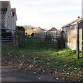
5
Vicarage Close, Ewyas Harold
Cul-de-sac of bungalows on the west side of Dark Lane.
Image: © Jaggery
Taken: 3 Dec 2017
0.05 miles
6
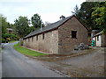
The Coach House, Ewyas Harold
25 metre (c82 ft) long single-storey house viewed across Dark Lane.
Image: © Jaggery
Taken: 9 Sep 2011
0.06 miles
7
Public footpath on the west side of Dark Lane, Ewyas Harold
A wooden public footpath sign is on the right.
Image: © Jaggery
Taken: 3 Dec 2017
0.06 miles
8
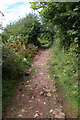
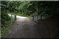
Track onto the Common
This is the path up onto Ewyas Harold Common from the village.
Image: © Hugh Venables
Taken: 13 Aug 2008
0.06 miles
9
The Glebe Close, Ewyas Harold
Cul-de-sac viewed from Dark Lane.
Image: © Jaggery
Taken: 3 Dec 2017
0.07 miles
10
Cattle grid onto common
There is now grazing again on the common, hence cattle grids on each of the entrances.
Image: © Hugh Venables
Taken: 13 Aug 2008
0.07 miles