IMAGES TAKEN NEAR TO
Michaelchurch Escley, HEREFORD, HR2 0JW
Introduction
This page details the photographs taken nearby to HR2 0JW by members of the Geograph project.
The Geograph project started in 2005 with the aim of publishing, organising and preserving representative images for every square kilometre of Great Britain, Ireland and the Isle of Man.

There are currently over 7.5m images from over14,400 individuals and you can help contribute to the project by visiting https://www.geograph.org.uk
Image Map
Images are licensed for reuse under creativecommons.org/licenses/by-sa/2.0
Notes
- Clicking on the map will re-center to the selected point.
- The higher the marker number, the further away the image location is from the centre of the postcode.
Image Listing (5 Images Found)
Images are licensed for reuse under creativecommons.org/licenses/by-sa/2.0
Image
Details
Distance
1
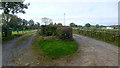
Twin entrances
Right to Rockyfold Farm, left to a different property.
Image: © Jonathan Billinger
Taken: 17 Oct 2015
0.04 miles
2
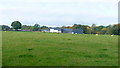
Rockyfold Farm
Viewed from Escley Lane; great name for a farm!
Image: © Jonathan Billinger
Taken: 17 Oct 2015
0.15 miles
3
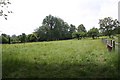
Meadow near Annedd Bach
The track on the right leads to Annedd Bach which was a ruin for years and was only converted to a private house relatively recently.
Image: © Bob Embleton
Taken: 31 May 2007
0.16 miles
4

Drive to The Old House
Drive and bridleway to The Old House near Michaelchurch Escley.
Image: © Philip Halling
Taken: 3 Dec 2011
0.16 miles
5
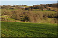
The Escley valley
The Escley Brook flows through this valley to the south-east of Michaelchurch Escley.
Image: © Philip Halling
Taken: 3 Dec 2011
0.23 miles