IMAGES TAKEN NEAR TO
Pontrilas, HEREFORD, HR2 0HF
Introduction
This page details the photographs taken nearby to HR2 0HF by members of the Geograph project.
The Geograph project started in 2005 with the aim of publishing, organising and preserving representative images for every square kilometre of Great Britain, Ireland and the Isle of Man.

There are currently over 7.5m images from over14,400 individuals and you can help contribute to the project by visiting https://www.geograph.org.uk
Image Map
Images are licensed for reuse under creativecommons.org/licenses/by-sa/2.0
Notes
- Clicking on the map will re-center to the selected point.
- The higher the marker number, the further away the image location is from the centre of the postcode.
Image Listing (10 Images Found)
Images are licensed for reuse under creativecommons.org/licenses/by-sa/2.0
Image
Details
Distance
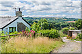
1
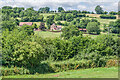
Pwll-yr-hunt
Looking across to Pwll-yr-hunt from near Vroe Farm.
Image: © Ian Capper
Taken: 8 Jul 2022
0.02 miles
2
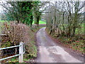
Lane to Pwll-yr-Hunt
Ascending the south side of the Cwm Brook valley.
Image: © Jonathan Billinger
Taken: 21 Jan 2012
0.10 miles
3
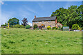
Upper Sunnybank
House near Sunnybank Farm.
Image: © Ian Capper
Taken: 8 Jul 2022
0.12 miles
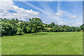
4
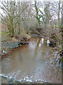
The Cwm Brook
Flowing away from the camera to merge with the Monnow system.
Image: © Jonathan Billinger
Taken: 21 Jan 2012
0.13 miles

8
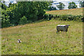
Cow and calf
Cow and calf in a field on Vroe Farm.
Image: © Ian Capper
Taken: 8 Jul 2022
0.21 miles
9
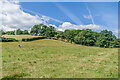
Field
Field with cows and calves in a field on Vroe Farm.
Image: © Ian Capper
Taken: 8 Jul 2022
0.22 miles
10
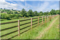
Paddocks
Path alongside horse paddocks on Vroe Farm. The house on the far left is Pwll-yr-hunt.
Image: © Ian Capper
Taken: 8 Jul 2022
0.22 miles