IMAGES TAKEN NEAR TO
The Nurdens, HEREFORD, HR1 4RG
Introduction
This page details the photographs taken nearby to The Nurdens, HR1 4RG by members of the Geograph project.
The Geograph project started in 2005 with the aim of publishing, organising and preserving representative images for every square kilometre of Great Britain, Ireland and the Isle of Man.

There are currently over 7.5m images from over14,400 individuals and you can help contribute to the project by visiting https://www.geograph.org.uk
Image Map
Images are licensed for reuse under creativecommons.org/licenses/by-sa/2.0
Notes
- Clicking on the map will re-center to the selected point.
- The higher the marker number, the further away the image location is from the centre of the postcode.
Image Listing (9 Images Found)
Images are licensed for reuse under creativecommons.org/licenses/by-sa/2.0
Image
Details
Distance
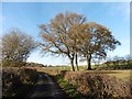
5
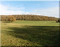
Field by Lenacres Ford
View through a fence ( a change from the usual high hedges) from The Nurdens (a road).
Image: © Richard Webb
Taken: 14 Apr 2016
0.16 miles
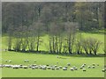
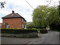
6
The Nurdens
A typical sounding Herefordshire name for this road - pure Call my Bluff. Passing Lenacres Ford.
Image: © Richard Webb
Taken: 14 Apr 2016
0.18 miles
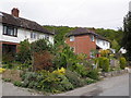
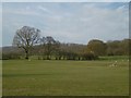
7
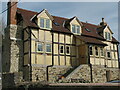
Cottages at Winslow Mill
Lies under Marcle Hill.
Image: © David M Clark
Taken: 2 Apr 2011
0.21 miles