IMAGES TAKEN NEAR TO
Lumber Lane, HEREFORD, HR1 4AG
Introduction
This page details the photographs taken nearby to Lumber Lane, HR1 4AG by members of the Geograph project.
The Geograph project started in 2005 with the aim of publishing, organising and preserving representative images for every square kilometre of Great Britain, Ireland and the Isle of Man.

There are currently over 7.5m images from over14,400 individuals and you can help contribute to the project by visiting https://www.geograph.org.uk
Image Map
Images are licensed for reuse under creativecommons.org/licenses/by-sa/2.0
Notes
- Clicking on the map will re-center to the selected point.
- The higher the marker number, the further away the image location is from the centre of the postcode.
Image Listing (162 Images Found)
Images are licensed for reuse under creativecommons.org/licenses/by-sa/2.0
Image
Details
Distance
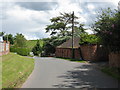
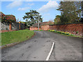
4
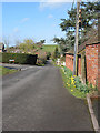
Lumber Lane junction with St.Peters Close
The lane heads north to join the A4103 passing Lugwardine Chapel on its way and crossing a Roman Road. Modern houses line St. Peters Close.
Image: © Pauline E
Taken: 11 Mar 2008
0.02 miles
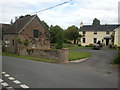
5
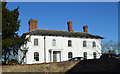
Porch House, Lugwardine
Fine late Georgian house of around 1830 which was the home of William Godwin, brick and tile manufacturer, from 1867. His famous factory was just down the lane behind the house.
Image: © Philip Pankhurst
Taken: 4 Dec 2016
0.03 miles
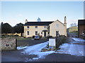
6
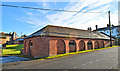
Stable block, Porch House
The house, once the home of tile and brick maker William Godwin, dates from around 1830, as does this handsome stable block.
Image: © Philip Pankhurst
Taken: 4 Dec 2016
0.03 miles
7
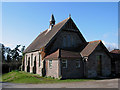
Rear of Lugwardine Chapel
Built at the end of the 19th century with funding from William Godwin, local tile maker. For many years it was known as Godwin's Chapel.
Image: © Pauline E
Taken: 11 Mar 2008
0.03 miles
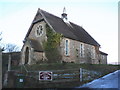
8
Lumber Lane, Lugwardine
Heading north from the A438, this passes Lugwardine Chapel and eventually crosses a Roman Road running east/west.
Image: © Pauline E
Taken: 11 Mar 2008
0.04 miles
9
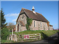
Lugwardine Chapel
Built in the final quarter of the 19th century with a beautiful tiled floor, and shown on the OS map 1905 as a Mission Room. William Godwin, a well-known tile maker, funded the building and it was known for many years after as Godwin's Chapel.
Image: © Pauline E
Taken: 11 Mar 2008
0.04 miles