IMAGES TAKEN NEAR TO
Bodenham, HEREFORD, HR1 3JD
Introduction
This page details the photographs taken nearby to HR1 3JD by members of the Geograph project.
The Geograph project started in 2005 with the aim of publishing, organising and preserving representative images for every square kilometre of Great Britain, Ireland and the Isle of Man.

There are currently over 7.5m images from over14,400 individuals and you can help contribute to the project by visiting https://www.geograph.org.uk
Image Map
Images are licensed for reuse under creativecommons.org/licenses/by-sa/2.0
Notes
- Clicking on the map will re-center to the selected point.
- The higher the marker number, the further away the image location is from the centre of the postcode.
Image Listing (7 Images Found)
Images are licensed for reuse under creativecommons.org/licenses/by-sa/2.0
Image
Details
Distance
1
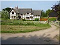
Timber-framed cottage
Thatched timber-framed cottage which may date from the late 16th century. The cottage is Grade II listed, see: https://historicengland.org.uk/listing/the-list/list-entry/1082027
Image: © Philip Halling
Taken: 5 Sep 2021
0.00 miles
2
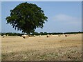
Oak tree and straw bales
An oak tree and straw bales in a stubble field at Upper Maund.
Image: © Philip Halling
Taken: 5 Sep 2021
0.12 miles
3
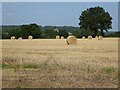
Straw bales at Upper Maund
Large round straw bales at Upper Maund.
Image: © Philip Halling
Taken: 5 Sep 2021
0.17 miles
4
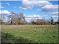
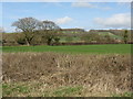
Upper Maund Common
Looking ESE. Area of common registered as 2.83 hectares.
Image: © Bob Embleton
Taken: 5 Apr 2006
0.18 miles
5
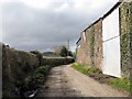
End Of The Road
Lower Maunds Farm is on the right. The footpath sign off to the left is just visible to the left of the telegraph pole in the distance, though rather shaded out by the tree.
Image: © Peter Whatley
Taken: 12 Mar 2009
0.20 miles
6
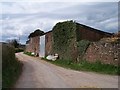
Farm buildings of Upper Maund Farm
Made of local red sandstone.
Image: © Bob Embleton
Taken: 16 Apr 2006
0.22 miles