IMAGES TAKEN NEAR TO
Morris Mews, HEREFORD, HR1 2BZ
Introduction
This page details the photographs taken nearby to Morris Mews, HR1 2BZ by members of the Geograph project.
The Geograph project started in 2005 with the aim of publishing, organising and preserving representative images for every square kilometre of Great Britain, Ireland and the Isle of Man.

There are currently over 7.5m images from over14,400 individuals and you can help contribute to the project by visiting https://www.geograph.org.uk
Image Map
Images are licensed for reuse under creativecommons.org/licenses/by-sa/2.0
Notes
- Clicking on the map will re-center to the selected point.
- The higher the marker number, the further away the image location is from the centre of the postcode.
Image Listing (1198 Images Found)
Images are licensed for reuse under creativecommons.org/licenses/by-sa/2.0
Image
Details
Distance
1
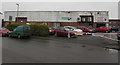
Hereford Snooker & Pool Centre, Hereford
On the south side of Coningsby Street.
Image: © Jaggery
Taken: 30 Jan 2017
0.02 miles
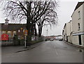
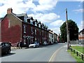
2
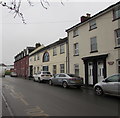
Housing variety, Coningsby Street, Hereford
Viewed from the Widemarsh Street end looking along Coningsby Street towards Canal Street.
The name on the house wall on the right is HARLEQUIN HOUSE.
Image: © Jaggery
Taken: 30 Jan 2017
0.03 miles
4
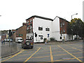
Row of houses, Coningsby Street, Hereford
Viewed in late January 2017. A November 2015 Google Earth Street View shows a similar incomplete paint job on the side wall.
Image: © Jaggery
Taken: 30 Jan 2017
0.03 miles
5
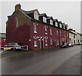
Coningsby Street, Hereford
Viewed across Widemarsh Street. St Thomas Cantilupe Church of England Primary School http://www.geograph.org.uk/photo/3502946 is on the left.
Image: © Jaggery
Taken: 30 Jan 2017
0.04 miles
6
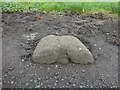
Old Boundary Stone, Coningsby Street, Hereford
The leftmost stone of three at this location on the Northern footpath of the road. Probably marking the various iterations of parish divisions in the city. In 1903 they were marking the boundary between the parishes of St Peter and St John the Baptist. The location of the stones can be seen on the RHS of Image The other two on https://www.geograph.org.uk/photo/7376801 & https://www.geograph.org.uk/photo/7376803.
A collection of similar images can be seen at https://www.geograph.org.uk/article/Boundary-Stones-of-the-City-of-Hereford
Milestone Society National ID: HF_HERE05pb
Image: © Mr Red
Taken: 6 Jan 2023
0.04 miles
7
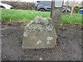
Old Boundary Stone, Coningsby Street, Hereford
On the Northern footpath of the road. The central one of three, probably marking the various iterations of parish divisions in the city. In 1903 they were marking the boundary between the parishes of St Peter and St John the Baptist. The location of the stones can be seen on the RHS of Image The other two on https://www.geograph.org.uk/photo/7376803 & https://www.geograph.org.uk/photo/7376802.
A collection of similar images can be seen at https://www.geograph.org.uk/article/Boundary-Stones-of-the-City-of-Hereford
Milestone Society National ID: HF_HERE06pb
Image: © Mr Red
Taken: 6 Jan 2023
0.04 miles
8
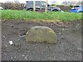
Old Boundary Stone, Coningsby Street, Hereford
The rightmost stone of three at this location on the Northern footpath of the road. Probably marking the various iterations of parish divisions in the city. In 1903 they were marking the boundary between the parishes of St Peter and St John the Baptist. The location of the stones can be seen on the RHS of Image The other two on https://www.geograph.org.uk/photo/7376801 & https://www.geograph.org.uk/photo/7376802.
A collection of similar images can be seen at https://www.geograph.org.uk/article/Boundary-Stones-of-the-City-of-Hereford
Milestone Society National ID: HF_HERE07pb
Image: © Mr Red
Taken: 6 Jan 2023
0.04 miles
10
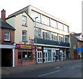
Kamal Tandoori, Hereford
Established in 1982, the Bangladeshi cuisine restaurant and takeaway is at 82 Widemarsh Street.
Image: © Jaggery
Taken: 13 Jan 2012
0.04 miles