IMAGES TAKEN NEAR TO
Walney Lane, HEREFORD, HR1 1JD
Introduction
This page details the photographs taken nearby to Walney Lane, HR1 1JD by members of the Geograph project.
The Geograph project started in 2005 with the aim of publishing, organising and preserving representative images for every square kilometre of Great Britain, Ireland and the Isle of Man.

There are currently over 7.5m images from over14,400 individuals and you can help contribute to the project by visiting https://www.geograph.org.uk
Image Map
Images are licensed for reuse under creativecommons.org/licenses/by-sa/2.0
Notes
- Clicking on the map will re-center to the selected point.
- The higher the marker number, the further away the image location is from the centre of the postcode.
Image Listing (14 Images Found)
Images are licensed for reuse under creativecommons.org/licenses/by-sa/2.0
Image
Details
Distance
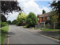
1
A465 north of Hereford
The lorry is heading into town along the Aylestone Hill Road.
Image: © Jonathan Billinger
Taken: 1 Sep 2010
0.08 miles
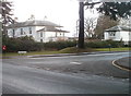
2
Walney Court, Walney Lane, Hereford
Located on the east side of Aylestone Hill. The notice between the trees states:
"An exclusive development of just SIX purpose built apartments"
Image: © Jaggery
Taken: 13 Jan 2011
0.09 miles
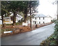
3
House on Aylestone Hill, Hereford
Showing position of Postbox No. HR1 106.
See Image] for postbox.
Image: © JThomas
Taken: 11 Aug 2021
0.11 miles
4
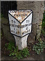
Old Milepost by the A465, Aylestone Hill, Hereford
Cast iron post by the A465, in parish of HEREFORD (Herefordshire), Aylestone Hill, junction with Broadlands Lane, house drive pillar, on East side of road. Hodges iron T-post, erected by the Hereford Turnpike Trust in the 19th century.
Inscription reads:-
: TO / HEREFORD / 1 / MILE : : HAMPTONBISHOP / PARISH : : TO / BROMYARD / 13 / MILES :
Maker:-
: C HODGES / & / SON / HEREFORD / FOUNDRY :
Grade II Listed. List Entry Number: 1196775
https://historicengland.org.uk/listing/the-list/list-entry/1196775
Milestone Society National ID: HF_HFBY01.
Image: © Milestone Society
Taken: 11 Mar 2017
0.12 miles
5
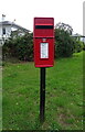
Elizabeth II postbox on Aylestone Hill, Hereford
Postbox No. HR1 106.
See Image] for context.
Image: © JThomas
Taken: 11 Aug 2021
0.13 miles
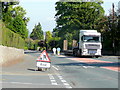
6
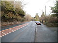
Northern descent of Aylestone Hill, Hereford
The A465 heads north out of Hereford towards the A4103.
Image: © Jaggery
Taken: 13 Jan 2011
0.14 miles
7
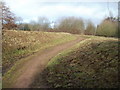
Hereford : track from Aylestone Hill to an open space
A track heads away from the western side of Aylestone Hill (A465) into an open space.
Image: © Jaggery
Taken: 13 Jan 2011
0.15 miles
8
Hereford : northern corner of Broadlands Lane and Aylestone Hill
Viewed across Aylestone Hill.
Image: © Jaggery
Taken: 13 Jan 2011
0.17 miles
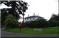
9
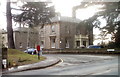
Athelstan Hall, Hereford
Built in the mid 19th century, Athelstan Hall is a grade II listed building on the southern corner of Broadlands Lane and Aylestone Hill.
Image: © Jaggery
Taken: 13 Jan 2011
0.17 miles