IMAGES TAKEN NEAR TO
Kingsway, HEREFORD, HR1 1HA
Introduction
This page details the photographs taken nearby to Kingsway, HR1 1HA by members of the Geograph project.
The Geograph project started in 2005 with the aim of publishing, organising and preserving representative images for every square kilometre of Great Britain, Ireland and the Isle of Man.

There are currently over 7.5m images from over14,400 individuals and you can help contribute to the project by visiting https://www.geograph.org.uk
Image Map
Images are licensed for reuse under creativecommons.org/licenses/by-sa/2.0
Notes
- Clicking on the map will re-center to the selected point.
- The higher the marker number, the further away the image location is from the centre of the postcode.
Image Listing (134 Images Found)
Images are licensed for reuse under creativecommons.org/licenses/by-sa/2.0
Image
Details
Distance
3
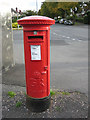
GR pillar box, College Road
At the junction of College Road/Burcott Road, by the Co-op.
Image: © Pauline E
Taken: 11 Oct 2008
0.06 miles
4
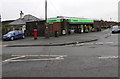
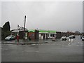
College Road Co-op, Hereford
The Co-operative Food store is at 1 College Road.
Image: © Jaggery
Taken: 11 Jan 2016
0.06 miles
5
Shop, Kingsway
Junction with College Road, Hereford.
Image: © Richard Webb
Taken: 26 Dec 2012
0.07 miles
6
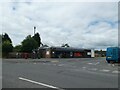
College Road Co-Op: June 2024
When I am out Geograph hunting, these shops are my friend. I am very cowardly about parking in town, and especially city centres; so I like places that stock my favourite pies, pasties, choccy bars and fizzy drinks where you can park without any stress!
Image: © Basher Eyre
Taken: 23 Jun 2024
0.07 miles
7
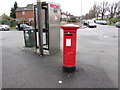
King George V pillarbox and BT phonebox on a Hereford corrner
Located here http://www.geograph.org.uk/photo/4793210 at a bend in College Road. The GR on the box is short for Georgius Rex, Latin for King George, in this case King George V who reigned from May 1910-January 1936.
Image: © Jaggery
Taken: 11 Jan 2016
0.07 miles
8
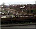
Railway NNW of Burcott Road, Hereford
Viewed from this http://www.geograph.org.uk/photo/4794727 footbridge. Hereford railway station is about 400 metres behind the camera.
Image: © Jaggery
Taken: 11 Jan 2016
0.07 miles
9
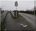
Weak bridge and parallel footbridge, College Road, Hereford
Crossing over railway lines about 400 metres NW of Hereford railway station.
The road bridge has a 7.5 tonnes MGW. MGW is maximum gross weight,
the maximum legally permitted weight of a vehicle, including fuel, load, driver, passengers etc.
Image: © Jaggery
Taken: 11 Jan 2016
0.07 miles
10
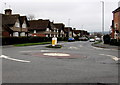
Mini-roundabout at a 3-way junction in Hereford
At the junction of Barrs Court Road (ahead), College Road (NE section) and College Road (western section).
Image: © Jaggery
Taken: 11 Jan 2016
0.08 miles