IMAGES TAKEN NEAR TO
Kings Crescent, HEREFORD, HR1 1GY
Introduction
This page details the photographs taken nearby to Kings Crescent, HR1 1GY by members of the Geograph project.
The Geograph project started in 2005 with the aim of publishing, organising and preserving representative images for every square kilometre of Great Britain, Ireland and the Isle of Man.

There are currently over 7.5m images from over14,400 individuals and you can help contribute to the project by visiting https://www.geograph.org.uk
Image Map
Images are licensed for reuse under creativecommons.org/licenses/by-sa/2.0
Notes
- Clicking on the map will re-center to the selected point.
- The higher the marker number, the further away the image location is from the centre of the postcode.
Image Listing (55 Images Found)
Images are licensed for reuse under creativecommons.org/licenses/by-sa/2.0
Image
Details
Distance
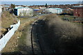
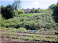
1
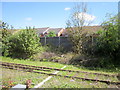
Railway Running Alongside Kings Crescent Hereford
Image: © Roy Hughes
Taken: 22 Apr 2017
0.02 miles
2
Burcott Road, Hereford, 2
Looking towards the constriction from the south.
Image: © Jonathan Billinger
Taken: 9 Jan 2017
0.11 miles
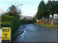
3
Burcott Road, Hereford, 1
This narrow public road is just wide enough for small cars to pass through.
Image: © Jonathan Billinger
Taken: 9 Jan 2017
0.12 miles
4
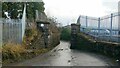
Site of Painter's
View up the course of the siding that served the Painter's pylon works. Many of the pylons adorning Geograph were born here. Of course like most factories, the site is all retail now, although Wiggin's metal works is hanging on to the north.
The track still in place serves Bulmers, once the company operated a steam locomotive George V here. It was a bypass to Hereford Station in the pre Beeching years.
Hereford was industrialised in the post war years, but many industries have gone.
Image: © Richard Webb
Taken: 26 Dec 2006
0.13 miles
5
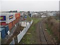
Branch line, Hereford
A branch line off the main line in Widemarsh, Hereford. Formerly the start of the line to Hay-on-Wye and Brecon, after closure in the early 1960s it became a siding serving the Bulmer Cider works. But this has been disused for some years.
The sign of a black cross on a white background top centre of the photo warns any train driver they are approaching the level crossing on Burcott Road
Image: © Philip Halling
Taken: 24 Jan 2009
0.14 miles
6
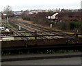
Railway NNW of Burcott Road, Hereford
Viewed from this http://www.geograph.org.uk/photo/4794727 footbridge. Hereford railway station is about 400 metres behind the camera.
Image: © Jaggery
Taken: 11 Jan 2016
0.14 miles
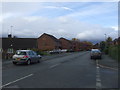
10
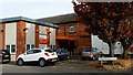
Diaverum; Hereford Kidney Treatment Centre
This privately-run clinic is used by a regional NHS hospital for patient kidney treatment.
It is on the corner of Mortimer Road and Perseverance Road.
Image: © Jonathan Billinger
Taken: 21 Oct 2016
0.16 miles