IMAGES TAKEN NEAR TO
Potkiln Lane, BEACONSFIELD, HP9 2XA
Introduction
This page details the photographs taken nearby to Potkiln Lane, HP9 2XA by members of the Geograph project.
The Geograph project started in 2005 with the aim of publishing, organising and preserving representative images for every square kilometre of Great Britain, Ireland and the Isle of Man.

There are currently over 7.5m images from over14,400 individuals and you can help contribute to the project by visiting https://www.geograph.org.uk
Image Map
Images are licensed for reuse under creativecommons.org/licenses/by-sa/2.0
Notes
- Clicking on the map will re-center to the selected point.
- The higher the marker number, the further away the image location is from the centre of the postcode.
Image Listing (18 Images Found)
Images are licensed for reuse under creativecommons.org/licenses/by-sa/2.0
Image
Details
Distance
1
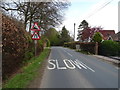
Potkiln Lane towards Jordans
Looking north east.
Image: © JThomas
Taken: 13 Apr 2019
0.01 miles
4
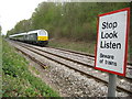
Jordans: Potkiln Lane railway bridge
Having duly stopped, looked, and listened, this is the view from Image The railway does not run symmetrically through the centre of the bridge and although it is not obvious from the photograph the bridge actually has three arches. This is the reverse view to Shaun's Image
Image: © Nigel Cox
Taken: 25 Apr 2010
0.04 miles
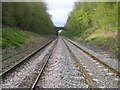
5
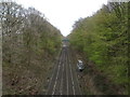
Railway towards Gerrards Cross
Looking south east from the bridge on Potkiln Lane.
Image: © JThomas
Taken: 13 Apr 2019
0.06 miles
6

Jordans: Birchland Wood
This track runs alongside the railway, heading here towards Potkiln Lane. The first sheen of summer foliage has just appeared.
Image: © Nigel Cox
Taken: 25 Apr 2010
0.09 miles
7
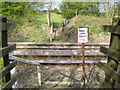
Jordans: Birchland Wood railway foot crossing (1)
It is gratifying that in 2010 with all kinds of health and safety regulations in place, and the need to produce risk assessments for every form of commercial activity, that the great British public are trusted to exercise their right to follow an ancient footpath route by crossing, with due care and attention of course, a main line railway.
Here an old footpath, shown on the Ordnance Survey 6" to the mile map of 1900, crosses the route of the London to Birmingham railway line which was completed in 1906.
Image: © Nigel Cox
Taken: 25 Apr 2010
0.13 miles
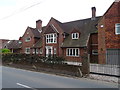
8
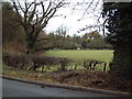
Field near Dean Wood
This field is by the junction of Long Bottom Lane and Potkiln Lane close to the old Quaker Meeting House at Jordans.
Image: © David Squire
Taken: 5 Dec 2005
0.13 miles
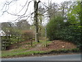
9
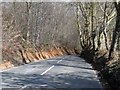
Steep hill near Dean Wood
The banks to this lane have the appearance of being ancient.
Image: © Bikeboy
Taken: 29 Mar 2013
0.14 miles
10
Jordans: Birchland Wood railway foot crossing (2)
Following on from Image here's the risk to be considered, in this case Wrexham and Shropshire's northbound 1619 hrs Sunday service from London Marylebone hurtling past.
Image: © Nigel Cox
Taken: 25 Apr 2010
0.16 miles