IMAGES TAKEN NEAR TO
Seer Green, BEACONSFIELD, HP9 2UR
Introduction
This page details the photographs taken nearby to HP9 2UR by members of the Geograph project.
The Geograph project started in 2005 with the aim of publishing, organising and preserving representative images for every square kilometre of Great Britain, Ireland and the Isle of Man.

There are currently over 7.5m images from over14,400 individuals and you can help contribute to the project by visiting https://www.geograph.org.uk
Image Map
Images are licensed for reuse under creativecommons.org/licenses/by-sa/2.0
Notes
- Clicking on the map will re-center to the selected point.
- The higher the marker number, the further away the image location is from the centre of the postcode.
Image Listing (15 Images Found)
Images are licensed for reuse under creativecommons.org/licenses/by-sa/2.0
Image
Details
Distance
1
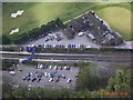
Aerial view of Seer Green Station
Taken looking southwards from police helicopter
Image: © Dennis Troughton
Taken: 11 Apr 2003
0.02 miles
2
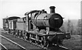
Up goods at Seer Green
View NW, towards High Wycombe and Princes Risborough on ex-GW&GC Paddington - Birmingham and Marylebone - Sheffield main lines. The locomotive is ex-GW Collett '2251' class 0-6-0 No. 2203 (built 8/39, withdrawn 6/60).
Image: © Ben Brooksbank
Taken: 25 Mar 1950
0.04 miles
3
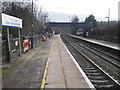
Seer Green & Jordans railway station
Opened as "Beaconsfield Golf Links" in April 1906 by the Great Western Railway and Great Central Railway on the line from London Marylebone to Princes Risborough. The station was originally only for golfers, opening to the public in December 1914. The name was changed to "Seer Green for Beaconsfield Golf Club" in 1918, then "Seer Green & Jordans" in 1950. "& Jordans" was dropped in 1974 but reappeared 1988-1992.
View south east towards Gerrards Cross and London.
Image: © Nigel Thompson
Taken: 16 Feb 2013
0.05 miles
4
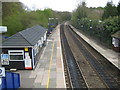
Seer Green and Jordans railway station
This station had its origins in the agreement that allowed the Great Western Railway and the Great Central Railway joint venture London to Birmingham line to pass through the Wilton Park estate near Beaconsfield. The owner of the estate, Colonel William du Pre, insisted that a halt be built adjacent to the golf course on the estate that he had just commissioned. The station duly opened in 1915 as Beaconsfield Golf Links halt, although the 1925 Ordnance Survey map shows it as Seer Green Halt. It was later rebranded to its current name to reflect its service to the two communities. This is the view from the footbridge.
Image: © Nigel Cox
Taken: 25 Apr 2010
0.05 miles
5
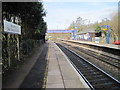
Seer Green & Jordans railway station
Opened as "Beaconsfield Golf Links" in April 1906 by the Great Western Railway and Great Central Railway on the line from London Marylebone to Princes Risborough. The station was originally only for golfers, opening to the public in December 1914. The name was changed to "Seer Green for Beaconsfield Golf Club" in 1918, then "Seer Green & Jordans" in 1950. "& Jordans" was dropped in 1974 but reappeared 1988-1992.
View north west towards Beaconsfield and Princes Risborough.
Image: © Nigel Thompson
Taken: 16 Feb 2013
0.06 miles
6
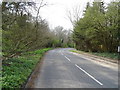
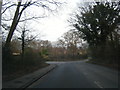
Longbottom Lane, Seer Green
Looking west beside woodland.
Image: © JThomas
Taken: 13 Apr 2019
0.12 miles
7
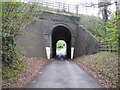
Beaconsfield Golf Club railway bridge
This unusual skewed narrow bridge would probably have been built around 1906 by the joint venture of the Great Western Railway and Great Central Railway to allow access through the new railway embankment to Colonel William Du Pre's Golf Club, as part of the commercial deal that allowed the London to Birmingham railway to pass through the Wilton Park estate. The golf course subsequently became the Beaconsfield Golf Club.
Image: © Nigel Cox
Taken: 25 Apr 2010
0.12 miles