IMAGES TAKEN NEAR TO
Pyebush Lane, BEACONSFIELD, HP9 2RX
Introduction
This page details the photographs taken nearby to Pyebush Lane, HP9 2RX by members of the Geograph project.
The Geograph project started in 2005 with the aim of publishing, organising and preserving representative images for every square kilometre of Great Britain, Ireland and the Isle of Man.

There are currently over 7.5m images from over14,400 individuals and you can help contribute to the project by visiting https://www.geograph.org.uk
Image Map
Images are licensed for reuse under creativecommons.org/licenses/by-sa/2.0
Notes
- Clicking on the map will re-center to the selected point.
- The higher the marker number, the further away the image location is from the centre of the postcode.
Image Listing (7 Images Found)
Images are licensed for reuse under creativecommons.org/licenses/by-sa/2.0
Image
Details
Distance
1
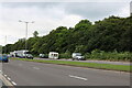
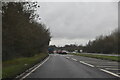
The A355, Beaconsfield
Connecting the area with the M40
Image: © David Howard
Taken: 24 Jun 2021
0.15 miles
2
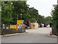
Timber yard
This South Bucks estates timber and fencing yard is on the former line of the A40.
Image: © David Hawgood
Taken: 31 Jul 2008
0.16 miles
4
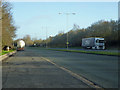
Beaconsfield: Pyebush Lane
This is now a dead end but prior to the building of the M40 Motorway Pyebush Lane carried on southwards to join up with the road, Windsor End, leading south out of the centre of Beaconsfield from here, while Hedgerley Lane crossed Pyebush Lane at this point. Hedgerley Lane still exists in two separate sections to the south and north of the motorway.
Image: © Nigel Cox
Taken: 25 Apr 2010
0.17 miles
6
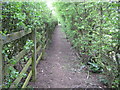
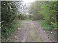
Beaconsfield: Footpath to Hedgerley
A green tunnel it might be but this is hardly the most alluring footpath in the Chilterns, passing as it does between the M40 Motorway immediately to the right, and a landfill site, eventually, to the left.
However this is a classic illustration of how positional accuracy on maps can be subsumed to the needs of cartography. Here, in order to show the motorway on the Ordnance Survey 1:50,000 scale maps, the footpath route has been shunted some 80 metres north of its true position as shown on more accurate larger scale maps. The circles showing the subject and photographer positions are correct located according to their co-ordinates but then show the photographer standing in the middle of the motorway slip road...!
Image: © Nigel Cox
Taken: 25 Apr 2010
0.23 miles
7
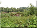
Overgrown roadside near Beaconsfield
View from the verge of the A40 London Road, just east of Pyebush Lane.
Image: © David Hawgood
Taken: 31 Jul 2008
0.24 miles