IMAGES TAKEN NEAR TO
One Tree Lane, BEACONSFIELD, HP9 2BU
Introduction
This page details the photographs taken nearby to One Tree Lane, HP9 2BU by members of the Geograph project.
The Geograph project started in 2005 with the aim of publishing, organising and preserving representative images for every square kilometre of Great Britain, Ireland and the Isle of Man.

There are currently over 7.5m images from over14,400 individuals and you can help contribute to the project by visiting https://www.geograph.org.uk
Image Map
Images are licensed for reuse under creativecommons.org/licenses/by-sa/2.0
Notes
- Clicking on the map will re-center to the selected point.
- The higher the marker number, the further away the image location is from the centre of the postcode.
Image Listing (11 Images Found)
Images are licensed for reuse under creativecommons.org/licenses/by-sa/2.0
Image
Details
Distance
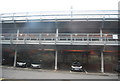
1
Beaconsfield: One Tree Lane
With apologies to Ronseal, it does exactly what it says on the tin...., not!
Image: © Nigel Cox
Taken: 26 Jul 2014
0.02 miles
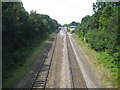
2
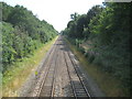
Beaconsfield: Railway towards London
The Great Western and Great Central Joint Railway opened their line through Beaconsfield in 1906, and as can be seen from this and other photographs of the railway in the vicinity it involved the excavation of a long cutting. This is the view looking eastwards and "up" towards London and the next station, Seer Green and Jordans, from the footbridge that now links Caledon Road and Maxwell Road. Ironically the footpath predates both the railway and the roads, and presumably the railway company had to build the bridge to maintain the public right of way. For a view in the opposite direction please see Image
Image: © Nigel Cox
Taken: 26 Jul 2014
0.09 miles
3
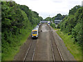
Chiltern Railways train passing Beaconsfield
A non-stop down train formed from three car diesel unit 168 219. If running to time, this would be the 12:35 Marylebone to Oxford Parkway.
Image: © Robin Webster
Taken: 18 Jun 2016
0.15 miles

9
Beaconsfield: Railway towards Beaconsfield station
The Great Western and Great Central Joint Railway opened their line through Beaconsfield in 1906, and as can be seen from this and other photographs of the railway in the vicinity it involved the excavation of a long cutting. This is the view looking westwards and "down" towards the station at Beaconsfield, from the footbridge that now links Caledon Road and Maxwell Road. Ironically the footpath predates both the railway and the roads, and presumably the railway company had to build the bridge to maintain the public right of way. The photograph clearly shows the gap where the original through non-stop lines ran, until they were lifted by British Rail in 1974. For a view in the opposite direction please see Image
Image: © Nigel Cox
Taken: 26 Jul 2014
0.23 miles