IMAGES TAKEN NEAR TO
Eastway, BEACONSFIELD, HP9 1DL
Introduction
This page details the photographs taken nearby to Eastway, HP9 1DL by members of the Geograph project.
The Geograph project started in 2005 with the aim of publishing, organising and preserving representative images for every square kilometre of Great Britain, Ireland and the Isle of Man.

There are currently over 7.5m images from over14,400 individuals and you can help contribute to the project by visiting https://www.geograph.org.uk
Image Map
Images are licensed for reuse under creativecommons.org/licenses/by-sa/2.0
Notes
- Clicking on the map will re-center to the selected point.
- The higher the marker number, the further away the image location is from the centre of the postcode.
Image Listing (27 Images Found)
Images are licensed for reuse under creativecommons.org/licenses/by-sa/2.0
Image
Details
Distance
1
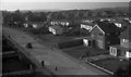
Holtspur, Mayflower Way, 1962
Photograph looking west along Mayflower Way, taken from the top of the tower of St Thomas's Church. The prefabricated houses (single storey) are no longer there.
Image: © Euchiasmus
Taken: Unknown
0.09 miles
2
Woodway, Beaconsfield
At the back of these houses is Cut-throat Wood which is seen in Image
Image: © David Hawgood
Taken: 7 Aug 2008
0.11 miles
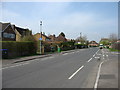
3
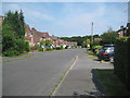
Holtspur: Heath Road
The town of Beaconsfield expanded greatly after the Second World War, and, to the west, swallowed up the hamlet of Holtspur. Heath Road is one of the western extremities of that expansion. The tops of the trees in Cut-throat Wood can be glimpsed over the roofs of the houses in the distance.
Image: © Nigel Cox
Taken: 26 Jul 2014
0.11 miles
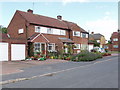
4
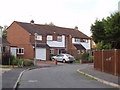
Long View, Beaconsfield
These houses are at the western extremity of Beaconsfield.
Image: © David Hawgood
Taken: 7 Aug 2008
0.12 miles
5
House with floral front garden in Heath Road, Beaconsfield
As I cycled round these roads I particularly noticed the flowers in the front garden with tall hollyhocks, climbers on frames, and plants in pots.
Image: © David Hawgood
Taken: 7 Aug 2008
0.13 miles
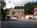
6
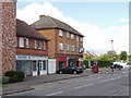
Shops in Holtspur Top Lane, Beaconsfield
There are more shops round the corner in Heath Road. Those in the photo include a post office, and a printing and graphics business.
Image: © David Hawgood
Taken: 7 Aug 2008
0.13 miles
8

Beaconsfield fire station
Beaconsfield fire station, 2 Skelton Close, Beaconsfield, Buckinghamshire
Image: © Kevin Hale
Taken: 13 Nov 2006
0.14 miles
9
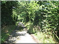
Holtspur: Glory Hill Lane
This lane used to connect Holtspur and Glory Mill until it was cut in two by the building of the M40 Motorway. No doubt confusingly to some visitors the remnant part on the other side of the motorway is called Glory Mill Lane, while this part is so-called because it is close to Glory Hill Farm. For a view of the lane in the adjacent grid square to the west please see Image
Image: © Nigel Cox
Taken: 26 Jul 2014
0.15 miles
10
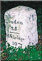
Old Milestone by the A40, west of Beaconsfield
Carved stone post by the A40, in parish of Beaconsfield (South Bucks District), White Hill; Holtspur, under trees on wide, ivy-covered verge, on South side of road. Beaconsfield diamond pillar, erected by the Beaconsfield & Stokenchurch turnpike trust in the 18th century.
Inscription reads:-
: Oxford / 29 / - / Wycombe / 4 : : London / 25 / - / Uxbridge / 10 : : XXV / Miles to / LONDON / 1744 :
Carved benchmark lower right face.
Buckinghamshire HER.
HER Number: 1362000000 https://www.heritagegateway.org.uk/Gateway/Results_Single.aspx?uid=MBC25814&resourceID=1024
Milestone Society National ID: BU_LW25
Image: © A Rosevear & J Higgins
Taken: 25 Oct 2001
0.15 miles