IMAGES TAKEN NEAR TO
Nightingales Lane, CHALFONT ST. GILES, HP8 4SP
Introduction
This page details the photographs taken nearby to Nightingales Lane, HP8 4SP by members of the Geograph project.
The Geograph project started in 2005 with the aim of publishing, organising and preserving representative images for every square kilometre of Great Britain, Ireland and the Isle of Man.

There are currently over 7.5m images from over14,400 individuals and you can help contribute to the project by visiting https://www.geograph.org.uk
Image Map
Images are licensed for reuse under creativecommons.org/licenses/by-sa/2.0
Notes
- Clicking on the map will re-center to the selected point.
- The higher the marker number, the further away the image location is from the centre of the postcode.
Image Listing (3 Images Found)
Images are licensed for reuse under creativecommons.org/licenses/by-sa/2.0
Image
Details
Distance
1
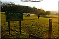
Path across the golf course
From here the public footpath heads straight to the corner of the wood. But is crosses two fairways. It may be better to consider diverting to the left, then following the edge of the wood.
Image: © Graham Horn
Taken: 16 Jan 2012
0.13 miles
2
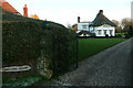
Thatched House
No house numbers in this area, just names. I was expecting the next one to be called Tiled House, but it wasn't.
Image: © Graham Horn
Taken: 16 Jan 2012
0.19 miles
3
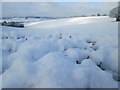
Snowy scene off Coke?s Lane
Although not immediately obvious, approximately two thirds of this photo is snow on top of a hedge.
Image: © Peter S
Taken: 23 Jan 2019
0.23 miles